Safety Score: 3,0 of 5.0 based on data from 9 authorites. Meaning we advice caution when travelling to United Kingdom.
Travel warnings are updated daily. Source: Travel Warning United Kingdom. Last Update: 2024-04-27 08:23:39
Delve into Framilode
Framilode in Gloucestershire (England) is located in United Kingdom about 98 mi (or 158 km) west of London, the country's capital town.
Current time in Framilode is now 06:15 AM (Sunday). The local timezone is named Europe / London with an UTC offset of one hour. We know of 9 airports close to Framilode, of which 5 are larger airports. The closest airport in United Kingdom is Gloucestershire Airport in a distance of 11 mi (or 18 km), North-East. Besides the airports, there are other travel options available (check left side).
There are several Unesco world heritage sites nearby. The closest heritage site in United Kingdom is Blaenavon Industrial Landscape in a distance of 23 mi (or 37 km), West. Also, if you like playing golf, there are some options within driving distance. We encountered 1 points of interest near this location. If you need a hotel, we compiled a list of available hotels close to the map centre further down the page.
While being here, you might want to pay a visit to some of the following locations: Gloucester, Lea, Charfield, Falfield and Linton. To further explore this place, just scroll down and browse the available info.
Local weather forecast
Todays Local Weather Conditions & Forecast: 10°C / 49 °F
| Morning Temperature | 3°C / 38 °F |
| Evening Temperature | 9°C / 48 °F |
| Night Temperature | 4°C / 40 °F |
| Chance of rainfall | 21% |
| Air Humidity | 73% |
| Air Pressure | 1006 hPa |
| Wind Speed | Moderate breeze with 12 km/h (7 mph) from South |
| Cloud Conditions | Overcast clouds, covering 100% of sky |
| General Conditions | Moderate rain |
Monday, 29th of April 2024
12°C (54 °F)
10°C (50 °F)
Light rain, fresh breeze, overcast clouds.
Tuesday, 30th of April 2024
14°C (57 °F)
10°C (50 °F)
Light rain, fresh breeze, overcast clouds.
Wednesday, 1st of May 2024
13°C (56 °F)
11°C (52 °F)
Light rain, gentle breeze, overcast clouds.
Hotels and Places to Stay
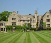
Stonehouse Court
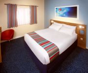
TRAVELODGE STONEHOUSE
Videos from this area
These are videos related to the place based on their proximity to this place.
Severn Bore March 2015
2 days after the solar eclipse the Severn experienced the highest tides for some time. A 10.4m predicted tide created a powerful bore ridden by many surfers and kayaks. There were even some...
5708 B10m citybus heads to weymouth.mov
Ex- Badgerline volvo B10M citybus 5708 (D708 GHY) heads south for the 2010 Weymouth bus rally. She still pops along at a comfortable 60mph, not bad for a nearly 25 year old double decker!
Back from the Brink Launch at WWT Slimbridge Wetland Centre
Back from the Brink video from http://www.soglos.com - Tuesday 28 July 2009 saw the launch of WWT Slimbridge Wetland Centre's brand new exhibit, with two beavers being released into their ...
Caribbean flamingo display (winter 2013)
Caribbean flamingos at WWT Slimbridge can feel the coming of spring...?
Land Rover Adventure Travel
The launch of Land Rover Adventure Travel by Abercrombie & Kent offers guests the chance to explore spectacular global destinations from behind the wheel in Land Rover's state of the art all-terrai...
Videos provided by Youtube are under the copyright of their owners.
Attractions and noteworthy things
Distances are based on the centre of the city/town and sightseeing location. This list contains brief abstracts about monuments, holiday activities, national parcs, museums, organisations and more from the area as well as interesting facts about the region itself. Where available, you'll find the corresponding homepage. Otherwise the related wikipedia article.
Westbury-on-Severn
Westbury-on-Severn is a rural village in England that is the centre of the large, rural parish, also called Westbury-on-Severn.
Whitminster Church
St. Andrew's Church in Whitminster, Gloucestershire is a village church constructed from Cotswold stone. The church site dates from 1086, although no part of the surviving fabric is visibly older than the 14th century. It was enlarged in 1842 to include a north aisle, designed by Bristol architect Thomas Foster, the tower was restored in 1844 and various other areas in 1884 by Sir A.W. Blomfeld, with the externals remaining mostly unchanged from that date.
Saul, Gloucestershire
Saul is a village in Gloucestershire, England at the site of the junction of the Stroudwater Navigation and the Gloucester and Sharpness Canal. It is in the parish of Fretherne with Saul in the district of Stroud. William John Westwood, the 36th Anglican Bishop of Peterborough was born in Saul.
Westbury Court Garden
Westbury Court Garden is a Dutch water garden in Westbury-on-Severn, Gloucestershire, England, 9 miles southwest of Gloucester. It was laid out in 1696–1705, a rare survival not to have been replaced in the 18th century by a naturalistic garden landscape as popularised by Capability Brown.
Framilode
Framilode is a village on the banks of the River Severn in Gloucestershire, England. It consists of two settlements, Lower Framilode (also known simply as Framilode) and Upper Framilode. It lies in the parish of Fretherne with Saul. The River Frome enters the Severn at Upper Framilode, and the name, first recorded in the 7th century, means "Frome crossing point", probably signifying a crossing of the Severn by the mouth of the Frome.
Fretherne Court
Fretherne Court was a handsome residential sporting mansion with picturesque grounds and deer park estate of some 676 acres, situated in the Severn Vale between the Gloucester and Sharpness Canal and the River Severn, in Fretherne, Gloucestershire. It was owned by the Darell family who were Baronets of Richmond Hill. It was built in around 1864 by Sir Edward Tierney who also enlarged Fretherne church from one aisle to three.
Rodley, Gloucestershire
Rodley is a settlement in Westbury-on-Severn parish, Forest of Dean District, Gloucestershire, England. It lies to the south east of Westbury-on-Severn, surrounded on three sides by a loop of the River Severn. Rodley has a tin church, known as Rodley Mission Church. This is a prefabricated church constructed in 1908 of galvanised metal over a wooden interior. It is used for occasional services.


