Safety Score: 2,7 of 5.0 based on data from 9 authorites. Meaning we advice caution when travelling to United States.
Travel warnings are updated daily. Source: Travel Warning United States. Last Update: 2024-04-29 08:03:39
Delve into Coppernose
Coppernose in Bucks County (Pennsylvania) is a town located in United States about 149 mi (or 240 km) north-east of Washington DC, the country's capital town.
Time in Coppernose is now 06:10 PM (Monday). The local timezone is named America / New York with an UTC offset of -4 hours. We know of 10 airports closer to Coppernose, of which 4 are larger airports. The closest airport in United States is Trenton Mercer Airport in a distance of 14 mi (or 23 km), South-East. Besides the airports, there are other travel options available (check left side).
There are two Unesco world heritage sites nearby. The closest heritage site in United States is Independence Hall in a distance of 33 mi (or 53 km), South. Also, if you like the game of golf, there are some options within driving distance. We saw 1 points of interest near this location. In need of a room? We compiled a list of available hotels close to the map centre further down the page.
Since you are here already, you might want to pay a visit to some of the following locations: Doylestown, Flemington, Trenton, Easton and Norristown. To further explore this place, just scroll down and browse the available info.
Local weather forecast
Todays Local Weather Conditions & Forecast: 27°C / 80 °F
| Morning Temperature | 16°C / 61 °F |
| Evening Temperature | 26°C / 79 °F |
| Night Temperature | 20°C / 68 °F |
| Chance of rainfall | 0% |
| Air Humidity | 57% |
| Air Pressure | 1016 hPa |
| Wind Speed | Gentle Breeze with 6 km/h (4 mph) from East |
| Cloud Conditions | Broken clouds, covering 74% of sky |
| General Conditions | Broken clouds |
Monday, 29th of April 2024
24°C (75 °F)
15°C (59 °F)
Broken clouds, gentle breeze.
Tuesday, 30th of April 2024
20°C (69 °F)
13°C (56 °F)
Light rain, gentle breeze, overcast clouds.
Wednesday, 1st of May 2024
19°C (66 °F)
17°C (63 °F)
Scattered clouds, light breeze.
Hotels and Places to Stay
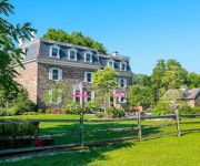
Woolverton Inn
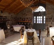
Logan Inn
Lumberville 1740 House
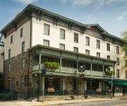
Lambertville House
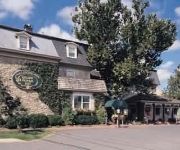
Golden Plough Inn
Videos from this area
These are videos related to the place based on their proximity to this place.
Water wheel Peddlers Village PA
Http:// www Videoscottsdale.com at water wheel at Golden Plaugh Inn and Peddersvillage in PA.
A Day in the Life of The PASS
This video, by Dave Tavani, follows a day in the life of a chef and his restaurant. Chefs Matthew Ridgway and Paul Mitchell have collaborated to create The Pass, a restaurant in Rosemont,...
Tony sale video
See http://equinenow.com/830926 2004 16.3 hand Oldenburg gelding. Tony has an exceptional disposition and temperament making him a pleasure to work with, extremely safe, uncomplicated and...
How to Determine an Appropriate Exposure for Waterfalls
An educational tutorial on the perception of how we actually view waterfalls. Comparing temporal and aesthetic values. The "ideal" exposure -- the shutter speed. The Wickecheoke Creek Hunterdon...
snowstorm 2010 backyard philadelphia new hope pa
backyard fun in the snow ginger and jake and a bit of gilda! in the end. shot and edited completely in the apple iphone 3gs using my favorite app 'vintage video maker'
Diesel Clinic with Felicitas
See http://equinenow.com/830924 Diesel, 2008 17 hand Dutch Gelding at a clinic in January 2014 with Felicitas Von Neumann Cosel.
Sheer shiny Pantyhose tease in heels
Sarah is enjoying her nude Philippe Matignon pantyhose. They are so shiny, she had to shoot a video! Paired with a beautiful pair of high-heel 6 1/2 inches sandals, her enjoyment can't be contained.
3350 Aquetong Road, Carversville, PA 18938
See the full tour at http://www.floorplanonline.com/95294 Quintessential Solebury vintage home in a Sylvan paradise setting. Residence dates back to the time of George Washington, with a lavish...
Videos provided by Youtube are under the copyright of their owners.
Attractions and noteworthy things
Distances are based on the centre of the city/town and sightseeing location. This list contains brief abstracts about monuments, holiday activities, national parcs, museums, organisations and more from the area as well as interesting facts about the region itself. Where available, you'll find the corresponding homepage. Otherwise the related wikipedia article.
Carversville, Pennsylvania
Carversville is an unincorporated community in Solebury Township, Bucks County, Pennsylvania, United States, approximately 45 miles north of Philadelphia. It was originally a Lenape gathering placed called Aquetong more than 300 years ago the area's land was granted to James Harrison and Joseph Pike by William Penn. The Paunacussing Creek also called Fleecydale runs through Carversville and meets the Delaware River at Lumberville.
Bull's Island Recreation Area
The 79-acre (32 ha) Bull's Island Recreation Area is on Bull's Island at Raven Rock along the Delaware River approximately 3 miles (5 km) north of Stockton, within Delaware Township in Hunterdon County, New Jersey, United States. The park is a part of the 3,578-acre (14 km²) Delaware and Raritan Canal State Park. It offers family campsites, a boat launch, fishing, and a nature trail. Canoes, kayaks, tubes, and rafts can be rented three miles north in Point Pleasant.
National Register of Historic Places listings in Bucks County, Pennsylvania
This is a list of the National Register of Historic Places listings in Bucks County, Pennsylvania. This is intended to be a complete list of the properties and districts on National Register of Historic Places in Bucks County, Pennsylvania. The locations of National Register properties and districts for which the latitude and longitude coordinates are included below, may be seen in a Google map. There are 156 properties and districts listed on the National Register in the county.
Lumberville – Raven Rock Bridge
The Lumberville – Raven Rock Bridge, also known as the Lumberville Foot Bridge, is a free pedestrian bridge over the Delaware River. The bridge connects Bull's Island Recreation Area near Raven Rock, Delaware Township in Hunterdon County, New Jersey to Lumberville, Solebury Township in Bucks County, Pennsylvania. The bridge, which is one of the two exclusively pedestrian bridges over the Delaware River, is owned and operated by the Delaware River Joint Toll Bridge Commission.
Hendrick Island
Hendrick Island is a large erosional feature in Bucks County, Pennsylvania. Once part of the main shoreline, a sizable channel of the Delaware River now separates it from the rest of the state. The island is part of Solebury Township and a protected natural area within Delaware Canal State Park.
Cuttalossa, Pennsylvania
Cuttalossa, Pennsylvania is an unincorporated hamlet in Solebury Township, just downriver from Lumberville, Pennsylvania. It sits at the confluence of a creek that runs through an unusually beautiful small valley and that feeds into the Delaware Division of the Pennsylvania Canal, an old barge canal formerly used for transporting coal and cement from Northern Pennsylvania to Philadelphia. The canal is now the Delaware Canal State Park.
Lumberville, Pennsylvania
Lumberville, Pennsylvania is a village on the Delaware River in Solebury Township, Bucks County, Pennsylvania, with a zip code of 18933. It is seven miles north of New Hope, Pennsylvania, and is located along River Road. The village was settled by Colonel George Wall, a Revolutionary War officer and Bucks County Sheriff. As such it was originally named Wall's Saw Mills and Walls Landing.
Point Pleasant, Pennsylvania
Point Pleasant is an unincorporated community in Tinicum and Plumstead Townships of Bucks County, Pennsylvania, United States. It lies on both sides of Tohickon Creek by the creek's confluence with the Delaware River; the creek is the dividing line between the townships. The ZIP code for the post office in Point Pleasant is 18950.


