Safety Score: 3,0 of 5.0 based on data from 9 authorites. Meaning we advice caution when travelling to France.
Travel warnings are updated daily. Source: Travel Warning France. Last Update: 2024-05-19 08:11:23
Explore Le Pied du Col
Le Pied du Col in Hautes-Alpes (Provence-Alpes-Côte d'Azur Region) is located in France about 325 mi (or 523 km) south-east of Paris, the country's capital.
Local time in Le Pied du Col is now 06:36 PM (Sunday). The local timezone is named Europe / Paris with an UTC offset of 2 hours. We know of 13 airports in the wider vicinity of Le Pied du Col, of which 5 are larger airports. The closest airport in France is L'alpe D'huez Airport in a distance of 14 mi (or 23 km), West. Besides the airports, there are other travel options available (check left side).
There are several Unesco world heritage sites nearby. The closest heritage site is Residences of the Royal House of Savoy in Italy at a distance of 64 mi (or 103 km). The closest in France is Historic Site of Lyons in a distance of 90 mi (or 103 km), East. If you need a place to sleep, we compiled a list of available hotels close to the map centre further down the page.
Depending on your travel schedule, you might want to pay a visit to some of the following locations: Saint-Jean-de-Maurienne, Briancon, Bardonecchia, Claviere and Cesana Torinese. To further explore this place, just scroll down and browse the available info.
Local weather forecast
Todays Local Weather Conditions & Forecast: 21°C / 69 °F
| Morning Temperature | 7°C / 45 °F |
| Evening Temperature | 13°C / 56 °F |
| Night Temperature | 9°C / 48 °F |
| Chance of rainfall | 2% |
| Air Humidity | 38% |
| Air Pressure | 1012 hPa |
| Wind Speed | Light breeze with 3 km/h (2 mph) from North-West |
| Cloud Conditions | Few clouds, covering 24% of sky |
| General Conditions | Light rain |
Monday, 20th of May 2024
16°C (60 °F)
9°C (49 °F)
Moderate rain, gentle breeze, overcast clouds.
Tuesday, 21st of May 2024
11°C (51 °F)
8°C (46 °F)
Moderate rain, light breeze, overcast clouds.
Wednesday, 22nd of May 2024
11°C (52 °F)
8°C (47 °F)
Light rain, gentle breeze, overcast clouds.
Hotels and Places to Stay
Hotel des Glaciers
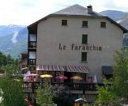
Le Faranchin
Videos from this area
These are videos related to the place based on their proximity to this place.
Наш Дом-villar d'Arene Франция 03-2012 часть 2
Monetier les Bains-Serre Chevalier-Briancon, Montgenevre-Cesana-Sestriere, Plevoux, Puy Saint Vincent, La Grave-Les 2 Alps Отчет http://ski.spb.ru/conf/index.php?showtopic=42464.
Harlem shake Tes3 (Saint Rom)
Harlem shake (Villar D'Arène) Tes3 - 2012/2013 - Lycée Saint Romain en Gal.
How to KiteLoop when gliding Tutorial (Jerome Josserand)
http://www.facebook.com/SuperKiteDay Jerome Josserand making it look easy. Awesome hill gliding action using the BAG CAM GoPro Hero, Location: Col du Lautaret France Testing the new IKON kite ...
Face sud du Pavé, Oisan
Avec Stephane, on a fait un "pavé dans la marre": 350m avec un 7b et trois 7a. à cette altitude, ça envoie ! 2h de marche en crampon 8h de grimpe 4h de rappel bien compliqués dans le froid...
Natural Xtreme Challenge - Team KiteDor
IF YOU LIKE IT, PLEASE LIKE THIS FACEBOOK POST: https://www.facebook.com/818787534869148 Film de la team kitedor (Delphine & Antoine) pour le natural Xtreme Challenge 2015.
Col du Lautaret
Eine Fahrt mit dem Mazda MX-5 und einer Roadstergruppe vom Col du Lautaret nach Le Le Monêtier-les-Bains im August 2012. Das Video zeigt die Fahrt in Echtzeit. Zum Teil mit 2 Onboard-Kameras.
snow park session au col du lautaret
Devant le chalet l'école kite légende, quand ça kite pas toute la journée parce qu'il n'y a plus de vent, ça taille du kicker et ça rigole en attendant le Snow Kite Master.
Ski de randonnée dans le massif des Ecrins
Quelques images prisent en novembre 2012 lors d'une sortie de ski (et snowboard) de randonnée au Combeynot, massif des Ecrins. Venez goûtez aux premières neiges avec Grenoble-Ecrins, ...
SKD SnowKiteMasters 2012 Trailer
Watch the full movie now http://www.youtube.com/watch?v=QKLFVw8k_WM http://www.facebook.com/SuperKiteDay Welcome back to the Col du Lautaret for the 2012SnowKiteMasters. This is a trailer...
Videos provided by Youtube are under the copyright of their owners.
Attractions and noteworthy things
Distances are based on the centre of the city/town and sightseeing location. This list contains brief abstracts about monuments, holiday activities, national parcs, museums, organisations and more from the area as well as interesting facts about the region itself. Where available, you'll find the corresponding homepage. Otherwise the related wikipedia article.
Jardin botanique alpin du Lautaret
The Jardin botanique alpin du Lautaret (Alpine botanical garden of Lautaret) (2 hectares) is an alpine botanical garden located at 2100 metres altitude in the Col du Lautaret of the Dauphiné Alps, near Villar-d'Arêne, Hautes-Alpes, Provence-Alpes-Côte d'Azur, France. It is open daily in the warmer months; an admission fee is charged. The garden was created in 1899 by combined effort of the Touring Club de France, Professor Jean-Paul Lachmann of the Université scientifique de Grenoble, and M.


