Safety Score: 3,0 of 5.0 based on data from 9 authorites. Meaning we advice caution when travelling to France.
Travel warnings are updated daily. Source: Travel Warning France. Last Update: 2024-05-24 08:16:39
Delve into Cras
Cras in Isère (Auvergne-Rhône-Alpes) with it's 347 habitants is a city located in France about 288 mi (or 463 km) south-east of Paris, the country's capital town.
Current time in Cras is now 04:38 PM (Friday). The local timezone is named Europe / Paris with an UTC offset of 2 hours. We know of 12 airports closer to Cras, of which 4 are larger airports. The closest airport in France is Grenoble-Isère Airport in a distance of 9 mi (or 14 km), North-West. Besides the airports, there are other travel options available (check left side).
There are several Unesco world heritage sites nearby. The closest heritage site in France is Historic Site of Lyons in a distance of 46 mi (or 73 km), North-West. We saw 2 points of interest near this location. In need of a room? We compiled a list of available hotels close to the map centre further down the page.
Since you are here already, you might want to pay a visit to some of the following locations: Grenoble, La Tour-du-Pin, Die, Belley and Chambery. To further explore this place, just scroll down and browse the available info.
Local weather forecast
Todays Local Weather Conditions & Forecast: 19°C / 66 °F
| Morning Temperature | 9°C / 48 °F |
| Evening Temperature | 15°C / 59 °F |
| Night Temperature | 12°C / 53 °F |
| Chance of rainfall | 5% |
| Air Humidity | 57% |
| Air Pressure | 1017 hPa |
| Wind Speed | Light breeze with 5 km/h (3 mph) from East |
| Cloud Conditions | Overcast clouds, covering 100% of sky |
| General Conditions | Moderate rain |
Saturday, 25th of May 2024
18°C (65 °F)
12°C (54 °F)
Light rain, light breeze, few clouds.
Sunday, 26th of May 2024
22°C (71 °F)
14°C (58 °F)
Overcast clouds, light breeze.
Monday, 27th of May 2024
17°C (62 °F)
13°C (55 °F)
Moderate rain, light breeze, overcast clouds.
Hotels and Places to Stay
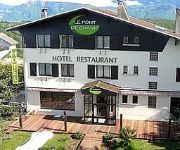
Le Pont de Champ Logis
Videos from this area
These are videos related to the place based on their proximity to this place.
Vive le France! Franska motorvägar är helt Fantastiska....
French highways are amazing.... 20090618.
Présentation vidéo des étangs de pêche de Renage (38140) gérés par l'APPR
Voici une petite vidéo présentant les 4 étangs de pêche de Renage et leur peuplement piscicole. Pour plus d'informations, visitez notre site internet (http://peche-renage-appr.fr)
Descente VTT - Col de PARMENIE - 15/05/2012 - Part1
Une journée de descente du Col de Parménie, avec Djazz et Oliv, qui avaient encore leurs vieux VTT, et moi le KONA Coilair. On refait les chemins de leurs enfances... Avec des dialogues épiques!!!
Aidez nous a trouver notre mere, Aline Penon!
Aline (Lilina) PENON, 68 ans, est atteinte de la maladie d'Alzheimer et a disparu le 03 mai 2013 de Vourey en Isere. Elle portait une parka beige, un gilet bleu marine, un pantalon marron,...
Camille Rimet Meille WhiteBoxSponsor
Voila ma participation au concours whiteboxshop :) Aimer , partager , liker :) :)
Entrainement d'un nouveau chasseur à l'arc...
Parcours à l'arc sur cibles 3D à Vinay (38) en compagnie de mon ami Charles. Pour ma part le gibier, n'a rien à craindre !!! Du moins pour l'instant... - http://eric-curetti.fr.
Videos provided by Youtube are under the copyright of their owners.
Attractions and noteworthy things
Distances are based on the centre of the city/town and sightseeing location. This list contains brief abstracts about monuments, holiday activities, national parcs, museums, organisations and more from the area as well as interesting facts about the region itself. Where available, you'll find the corresponding homepage. Otherwise the related wikipedia article.
Morge (Isère)
The Morge is a small river in eastern France, right tributary of the river Isère. Its source is near the Col de Saint-Roch, northeast of Voiron. It flows through Voiron, and joins the Isère south of Voiron, opposite the town Saint-Quentin-sur-Isère.
Château de l'Alba
Château de l'Alba is a château in L'Albenc, Isère, France. Built in the 15th century, it was renewed in the 18th century. It became a historic monument in 1978.


