Safety Score: 3,0 of 5.0 based on data from 9 authorites. Meaning we advice caution when travelling to United Kingdom.
Travel warnings are updated daily. Source: Travel Warning United Kingdom. Last Update: 2024-04-26 08:02:42
Delve into Derryork
Derryork in Causeway Coast and Glens (Northern Ireland) is a town located in United Kingdom about 367 mi (or 590 km) north-west of London, the country's capital town.
Time in Derryork is now 12:04 PM (Friday). The local timezone is named Europe / London with an UTC offset of one hour. We know of 11 airports closer to Derryork, of which 5 are larger airports. The closest airport in United Kingdom is Ballykelly Airport in a distance of 9 mi (or 15 km), North-West. Besides the airports, there are other travel options available (check left side).
There is one Unesco world heritage site nearby. The closest heritage site is Brú na Bóinne - Archaeological Ensemble of the Bend of the Boyne in Ireland at a distance of 102 mi (or 164 km). Also, if you like the game of golf, there is an option about 17 mi (or 27 km). away. In need of a room? We compiled a list of available hotels close to the map centre further down the page.
Since you are here already, you might want to pay a visit to some of the following locations: Limavady, Coleraine, Cookstown, Magherafelt and Ballymoney. To further explore this place, just scroll down and browse the available info.
Local weather forecast
Todays Local Weather Conditions & Forecast: 9°C / 48 °F
| Morning Temperature | 4°C / 39 °F |
| Evening Temperature | 7°C / 45 °F |
| Night Temperature | 3°C / 37 °F |
| Chance of rainfall | 0% |
| Air Humidity | 62% |
| Air Pressure | 1007 hPa |
| Wind Speed | Gentle Breeze with 7 km/h (4 mph) from South |
| Cloud Conditions | Overcast clouds, covering 90% of sky |
| General Conditions | Light rain |
Saturday, 27th of April 2024
10°C (50 °F)
4°C (38 °F)
Light rain, light breeze, scattered clouds.
Sunday, 28th of April 2024
11°C (52 °F)
7°C (45 °F)
Light rain, light breeze, clear sky.
Monday, 29th of April 2024
10°C (51 °F)
7°C (44 °F)
Light rain, gentle breeze, overcast clouds.
Hotels and Places to Stay
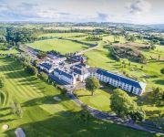
Roe Park Resort
Videos from this area
These are videos related to the place based on their proximity to this place.
The Future of Waste Resource Management
This is an 15 minute presentation on the challenges faced by our region in terms of managing our waste in the future. The video includes detailed descriptions of the Reduce, Reuse and Recycle...
Full Life Cycle of Dungiven Thunderstorm (HD) - May 26th 2014
Stunning thunderstorm which we watched though its entire life cycle along a convergence zone over Dungiven filmed from Benbradagh Mountain, N. Ireland. We watched this storm for over two hours...
UHPC at Dungiven
Members of the Ulster Hang gliding and Paragliding Club at Dungiven sites in the late 1990s. Featuring Ken McConnell, Chris Ungermann, Richard Stewart, Billy Reed, Davy Christie, Bertie Kennedy...
dungiven sungliders N Ireland cloudsurferireland.com
paragliding dungiven west in a ING sunglider first in Ireland ,GGGGrrreat wing.
powered paraglider take off at dungiven northern ireland 2011-11-05-16-25-14.mp4
at dungiven northern ireland 2011-11-05-16-25-14.mp4.
Videos provided by Youtube are under the copyright of their owners.
Attractions and noteworthy things
Distances are based on the centre of the city/town and sightseeing location. This list contains brief abstracts about monuments, holiday activities, national parcs, museums, organisations and more from the area as well as interesting facts about the region itself. Where available, you'll find the corresponding homepage. Otherwise the related wikipedia article.
Drumsurn
Drumsurn is a small village and townland in the Limavady Borough Council area of County Londonderry, Northern Ireland. It is 8 kilometres southeast of Limavady and 10 kilometres northeast of Dungiven. It lies in the Roe Valley, at the foot of Donald's Hill and at the edge of the Sperrins. Drumsurn had a population of 357 people in the 2001 Census.
Kevin Lynch's Hurling Club
Kevin Lynch's Hurling Club (Irish: Cumann lomanaíochta Chaoímhín Uí Loínsigh) is a Gaelic Athletic Association club based in Dungiven, County Londonderry, Northern Ireland. They currently cater for hurling. The Gaelic football and Ladies' Gaelic football team in the town is St. Canice's GAC.
Dungiven GAC
St Canice's GAC Dungiven (Irish: Cumann Chainnigh Naofa Dún Geimhin) is a Gaelic Athletic Association club based in Dungiven, Northern Ireland, and is part of Derry GAA. It currently caters for Gaelic football and Ladies' Gaelic football. The hurling club in the town is Kevin Lynch's. The club's biggest success was when it won the 1997 Ulster Senior Club Football Championship.
Drumsurn GAC
Saint Matthew's Gaelic Athletic Club (Irish: CLG Naomh Maitiú Droim Soirn) is a Gaelic Athletic Association club based in Drumsurn, County Londonderry, Northern Ireland. The club is affiliated to Derry GAA and currently competes in Gaelic football and camogie. Underage teams up to U-12s play in North Derry league and championships, from U-14 upwards teams compete in All-Derry competitions. Drumsurn fields Gaelic football teams at U-8, U-10, U-12, U-14 and Senior levels.
Dungiven Castle
Dungiven Castle, in Dungiven, County Londonderry, Northern Ireland, dates back to the seventeenth century although most of the current building dates from the 1830s. Following a mixed history, which saw it hosting housing the US Army during World War II, and later being used as a dance hall during the 1950s and 1960s, the castle fell into such a state of disrepair that the local council decided to demolish it.


