Safety Score: 3,5 of 5.0 based on data from 9 authorites. Meaning please reconsider your need to travel to Turkey.
Travel warnings are updated daily. Source: Travel Warning Turkey. Last Update: 2024-04-29 08:03:39
Delve into Dodurga
Dodurga in Muğla is a town located in Turkey about 314 mi (or 505 km) south-west of Ankara, the country's capital town.
Time in Dodurga is now 07:22 PM (Monday). The local timezone is named Europe / Istanbul with an UTC offset of 3 hours. We know of 9 airports closer to Dodurga, of which 5 are larger airports. The closest is airport we know is Kastelorizo Airport in Greece in a distance of 27 mi (or 44 km). The closest airport in Turkey is Dalaman International Airport in a distance of 32 mi (or 44 km), South-East. Besides the airports, there are other travel options available (check left side).
There are several Unesco world heritage sites nearby. The closest heritage site in Turkey is Xanthos-Letoon in a distance of 8 mi (or 13 km), South-East. In need of a room? We compiled a list of available hotels close to the map centre further down the page.
Since you are here already, you might want to pay a visit to some of the following locations: Esen, Kalkan, Fethiye, Kemer and Yesiluzumlu. To further explore this place, just scroll down and browse the available info.
Local weather forecast
Todays Local Weather Conditions & Forecast: 28°C / 83 °F
| Morning Temperature | 19°C / 67 °F |
| Evening Temperature | 23°C / 74 °F |
| Night Temperature | 22°C / 71 °F |
| Chance of rainfall | 0% |
| Air Humidity | 33% |
| Air Pressure | 1012 hPa |
| Wind Speed | Gentle Breeze with 7 km/h (4 mph) from North-East |
| Cloud Conditions | Clear sky, covering 0% of sky |
| General Conditions | Sky is clear |
Tuesday, 30th of April 2024
29°C (83 °F)
20°C (69 °F)
Sky is clear, gentle breeze, clear sky.
Wednesday, 1st of May 2024
27°C (81 °F)
20°C (68 °F)
Scattered clouds, gentle breeze.
Thursday, 2nd of May 2024
27°C (81 °F)
20°C (69 °F)
Few clouds, light breeze.
Hotels and Places to Stay
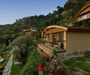
Lissiya Hotel
Videos from this area
These are videos related to the place based on their proximity to this place.
Lykien für Genießer: Wandern, Natur, Strand - ReNatour
Eingebettet in hochaufragende Gebirgszüge mit einem traumhaften Blick auf das Ägäische Meer liegt das Landhotel versteckt in einem großen Bergterrassengarten. Die ehemalige Wassermühle...
Letoon in Lykien
Der Letoon beherbergt das Hauptheiligtum der Lykier. Zu sehen ist ein Theater und die Tempel der Göttinen Leto und Arthemis und des Gottes Apollo. Archäologischer Reiseführer, Beschreibungen,...
Turkey hiking the Lycian Way 5 Guavagiri to Patara with Letoon and Xanthos
Video images from Lycian way.
Xanthos - Turkey
Xanthos - Kinik. On the way from Fethiye to Kaş you pass Xanthos, a nice antik excavation of one of the nineteen important cities of the Lycian alliance.
トルコの世界遺産 クサントス・レトゥーン
2012-05-25 トルコの世界遺産 クサントス・レトゥーン 10の世界遺産を巡るトルコ感動の15日間、9日目です。 ブログは↓ http://www.k4.dion.ne.jp/~skazuo/uri/...
Xanthos in Lykien
Xanthos ist eine der größten antiken Städte von Lykien mit Theater, Agora, Akropolis und einer Basilika. Sehenswert ist auch das Harpyien-Monument. Archäologischer Reiseführer, Beschreibung...
BMW e39 530d on German Autobahn at night
BMW e39 530d autoban germany at night, easy cruise http://www.seogo.lt/
Pinara in Lykien
Pinara ist eine antike Stadt im Westen von Lykien mit Theater, Odeon und vielen Felsgräbern. In der Felswand oberhalb der Stadt sind Hunderte davon. Archäologischer Reiseführer, Beschreibungen,...
Videos provided by Youtube are under the copyright of their owners.
Attractions and noteworthy things
Distances are based on the centre of the city/town and sightseeing location. This list contains brief abstracts about monuments, holiday activities, national parcs, museums, organisations and more from the area as well as interesting facts about the region itself. Where available, you'll find the corresponding homepage. Otherwise the related wikipedia article.
Mount Cragus
Mount Cragus or Mount Cragos or Mount Kragos – also recorded as Hiera Acra – is a mountain in Turkey, in what was formerly ancient Lycia, Asia Minor. Strabo (p. 665), whose description proceeds from west to east, after the promontory Telmissus, mentions Anticragus, on which is Carmylessus, and then Cragus, which has eight summits (or he may mean capes), and a city of the same name. Pinara, in the interior, was at the base of Cragus.


