Safety Score: 2,7 of 5.0 based on data from 9 authorites. Meaning we advice caution when travelling to United States.
Travel warnings are updated daily. Source: Travel Warning United States. Last Update: 2024-05-10 08:04:54
Delve into Melones
Melones in Calaveras County (California) is located in United States about 2,330 mi (or 3,749 km) west of Washington DC, the country's capital town.
Current time in Melones is now 03:29 AM (Friday). The local timezone is named America / Los Angeles with an UTC offset of -7 hours. We know of 10 airports close to Melones, of which 5 are larger airports. The closest airport in United States is Oakdale Airport in a distance of 24 mi (or 39 km), South-West. Besides the airports, there are other travel options available (check left side).
Also, if you like playing golf, there are some options within driving distance. We encountered 1 points of interest near this location. If you need a hotel, we compiled a list of available hotels close to the map centre further down the page.
While being here, you might want to pay a visit to some of the following locations: Sonora, San Andreas, Jackson, Modesto and Merced. To further explore this place, just scroll down and browse the available info.
Local weather forecast
Todays Local Weather Conditions & Forecast: 22°C / 71 °F
| Morning Temperature | 9°C / 49 °F |
| Evening Temperature | 20°C / 69 °F |
| Night Temperature | 12°C / 53 °F |
| Chance of rainfall | 0% |
| Air Humidity | 27% |
| Air Pressure | 1014 hPa |
| Wind Speed | Gentle Breeze with 8 km/h (5 mph) from North-East |
| Cloud Conditions | Clear sky, covering 0% of sky |
| General Conditions | Sky is clear |
Friday, 10th of May 2024
23°C (74 °F)
13°C (55 °F)
Sky is clear, gentle breeze, clear sky.
Saturday, 11th of May 2024
24°C (74 °F)
13°C (56 °F)
Sky is clear, gentle breeze, clear sky.
Sunday, 12th of May 2024
24°C (75 °F)
14°C (58 °F)
Sky is clear, gentle breeze, clear sky.
Hotels and Places to Stay
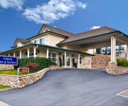
BEST WESTERN CEDAR INN
Historic National Hotel
The Palm Hotel
Gold Country Inn Angels Camp
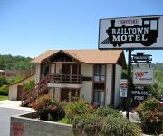
Jamestown Railtown Motel
JUMPING FROG MOTEL ANGELS CAMP
WORLDMARK ANGELS CAMP
AMERICAS BEST VALUE INN
TRAVELODGE ANGELS CAMP
Videos from this area
These are videos related to the place based on their proximity to this place.
Placer Varsity Girls Cross Country at Sac Joajuin Subsection 2014
Rough edit of video of Placer High School Varsity Girls Cross Country team competing in Division 3 of the Sac-Joaquin Subsections. Placer Varsity Girls were second place. The order of their...
S-2AT's Departing and Landing at Columbia Airport O22 with random Deer at the end
Multiple Takeoffs and Landings at Columbia Air Attack Base California. I believe these are the S-2AT civil firefighting conversion of the S-2 Tracker, but not the Convair Firecat version.
A Snake, A Landing, A Tombstone, and another Landing
Filmed from the Springfield cemetary, a 19th century cemetary just off the end of Columbia Airport.
Roger Racing a 1988-89 Accord Sedan on American Dad
Roger gets upset being behind a 1988-89 Accord Sedan and races them This Clip is from American Dad which is property of Fox Networks.
Woods Creek 1/7/2013
I take pictures and video of the small stream across the street from my mothers place....
Climbing at Jailhouse Sonora: Soap On A Rope 5.13a (7c+)
Anton (10 y.o) is working on "Soap on a rope".
Powered by Visalus-Kyle Burks debut MMA fight
Preperation: Visalus shakes twice a day (the Fit Kit) and a lot of sweat and hard work....Fight Day: 20 seconds into round one and....Winner by Knock Out (1-0). Go to www.ninetyforlife.myvi.net...
Moaning Caverns -- Adventure/Travel Host: Jasen Wade
Here is an adventurous tour of Moaning Caverns in Northern California. Dagen and I headed out to film some footage for a hosting reel I am putting together for Discovery Channel, and this...
Shasta at Moaning Caverns
Looking for fun things to do this summer? Why not go to Moaning Cavern in Vallecito, California. There are a lot of exciting activities for all ages. In this video you can see Shasta Garcia,...
Moaning-Cavern-Ziplines.mov
This video shows the thriling and fun zip line rides available at Moaning Cavern Adventure Park, every day year round!
Videos provided by Youtube are under the copyright of their owners.
Attractions and noteworthy things
Distances are based on the centre of the city/town and sightseeing location. This list contains brief abstracts about monuments, holiday activities, national parcs, museums, organisations and more from the area as well as interesting facts about the region itself. Where available, you'll find the corresponding homepage. Otherwise the related wikipedia article.
Carson Hill, California
Carson Hill (also, Carson Flat and Melones and Slumgullion) is a ghost town in Calaveras County, California. It sits at an elevation of 1447 feet (441 m) above sea level and is located at {{#invoke:Coordinates|coord}}{{#coordinates:38|01|42|N|120|30|24|W| | |name= }}, about 4 miles south-southeast of Angels Camp. It was one of the most productive mining camps in the state, with nearly $26 million in gold and quartz found in the area.
Melones, California
For the existing town formerly called Melones, see Carson Hill, California.
Archie Stevenot Bridge
The Stevenot Bridge carries State Route 49 over New Melones Lake between Calaveras and Tuolumne Counties in the U.S. state of California and was completed in 1976.
New Melones Lake
New Melones Lake is an artificial lake in the central Sierra Nevada foothills of Calaveras- and Tuolumne County, California, United States near Jamestown. This reservoir created by the construction of the New Melones Dam across the Stanislaus River has a 2,400,000 acre·ft capacity with a surface area of 12,500 acres . When full, the shoreline is more than 100 miles .


