
Facts and Data
Webpages:
Official Unesco Page
Basis Data:
Unesco World heritage since: 2011
Size of heritage: 12,290 ha
Coordinates:
Longitude: 36,844°
Latitude: 36,334°
Summary
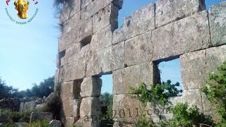
Some 40 villages grouped in eight parks situated in north-western Syria provide remarkable testimony to rural life in late Antiquity and during the Byzantine period. Abandoned in the 8th to 10th centuries, the villages, which date from the 1st to 7th centuries, feature a remarkably well preserved landscape and the architectural remains of dwellings, pagan temples, churches, cisterns, bathhouses etc. The relict cultural landscape of the villages also constitutes an important illustration of the transition from the ancient pagan world of the Roman Empire to Byzantine Christianity. Vestiges illustrating hydraulic techniques, protective walls and Roman agricultural plot plans furthermore offer testimony to the inhabitants' mastery of agricultural production.
Location on Map
Show bigger map on Openstreetmap
Ancient Villages of Northern Syria
The Ancient Villages of Northern Syria is a UNESCO World Heritage site located in the northern part of Syria. This site encompasses a collection of well-preserved ancient villages that provide a glimpse into the rich history and cultural heritage of the region. The coordinates for this site are N36 20 3 E36 50 39.
History
The history of the Ancient Villages of Northern Syria dates back thousands of years. These villages were once thriving centers of civilization and played a significant role in the development of the region. The area was inhabited by various civilizations, including the Hittites, Assyrians, Persians, Greeks, Romans, and Byzantines.
During the Roman period, the villages flourished as agricultural centers, benefiting from the fertile lands and strategic location along trade routes. The villages were known for their production of olive oil, wine, and other agricultural products. The Roman influence can still be seen in the architectural style and layout of some of the villages.
In the 7th century, the region came under Islamic rule, and the villages continued to thrive. They served as important centers for trade, education, and religious activities. The villages were known for their mosques, madrasas (Islamic schools), and caravanserais (inns for travelers).
Current State
Unfortunately, the Ancient Villages of Northern Syria have suffered significant damage and destruction due to the ongoing conflict in the country. The site has been severely impacted by the Syrian Civil War, which began in 2011. The conflict has resulted in the displacement of millions of people and the destruction of numerous cultural heritage sites.
Many of the ancient villages have been damaged or destroyed by bombings, looting, and deliberate acts of vandalism. The architectural treasures, including historic houses, mosques, and other structures, have been reduced to rubble. The once vibrant and bustling villages now lie in ruins, bearing witness to the devastating consequences of war.
The destruction of the Ancient Villages of Northern Syria is not only a loss for the Syrian people but also for humanity as a whole. These villages were a testament to the rich cultural heritage and historical significance of the region. They provided valuable insights into the lives and traditions of the people who once inhabited them.
Efforts are being made by international organizations, such as UNESCO, to document and preserve what remains of the ancient villages. However, the ongoing conflict and the unstable security situation in the region make it challenging to carry out comprehensive restoration and conservation work.
The Ancient Villages of Northern Syria, once a vibrant testament to the region's rich history, now stand as a stark reminder of the devastating impact of war on cultural heritage. It is hoped that peace will be restored to the region, allowing for the reconstruction and preservation of these invaluable sites for future generations to appreciate and learn from.
Videos from the area

Alep: St. Siméon- pillage et campement militaire حلب - دير سمعان : تنقيبات سرية ومعسكر تدريب
Alep: Monastère de St. Siméon- pillage et campement militaire حلب - دير سمعان : تنقيبات سرية ومعسكر تدريب Association for the Protection of Syrian Archaeology...
Videos provided by Youtube are under the copyright of their owners. 
 Aleppo International Airport
Large airport - 24 mi (39 km)
 Hatay Airport
Medium airport - 31 mi (51 km)
İskenderun AirportSmall airport - 42 mi (68 km)
Gaziantep International AirportLarge airport - 55 mi (89 km)
Bassel Al-Assad International AirportLarge airport - 82 mi (132 km)
Kahramanmaraş AirportMedium airport - 83 mi (135 km)
Adana AirportLarge airport - 98 mi (157 km)
Şanlıurfa AirportMedium airport - 123 mi (198 km)
Bigger and popular cities in the wider vicinity are these:
- Ad Dana
- Al Atarib
- Al Hadir
- Al Ma`batli
- Aleppo
- Armanaz
- Az Zarbah
- Binnish
- Bulbul
- Darat `Izzah
- Harim
- Huraytan
- I`zaz
- Jindayris
- Kafr Takharim
- Kumlu
- Ma`arratmisrin
- Mari`
- Nubl
- Qarqania
- Qentere
- Radjun
- Reyhanli
- Sharan
- Shaykh al Hadid
- Suran
- Taftanaz
- Tall Rif`at
- Yalangoz
- `Afrin
These are some smaller cities that might be interesting. They are all rather close.