Mozambique
in Eastern Africa
Africa
 Malawi
 South Africa
 Swaziland
 Tanzania
 Zambia
 Zimbabwe
- Currency and Currency Code:
- Meticail - MZN
- Spoken languages:
- Portuguese
- Local electricity:
- 220 V - 50 Hz (plugs: C, F, M)
- Mobile phone / cellular frequencies (MHz):
- 900 MHz, 1800 MHz, 3G, 4G
- ISO 2-Letter code:
- MZ
- Internet top level domain:
- .mz
- Country phone prefix:
- +258
- Local Time (capital):
- Timezone:
- UTC/GMT offset: hours
Safety Score: 3,0 of 5.0 based on data from 9 authorites. Meaning we advice caution when travelling to Mozambique.
Travel warnings are updated daily. Source: Travel Warning Mozambique. Last Update: 2024-04-26 08:02:42
Explore Mozambique
Mozambique with its capital Maputo is located in Africa (Southeastern Africa, bordering the Mozambique Channel). It covers some 799,381 square kilometers (slightly more than five times the size of Georgia) with 26,573,700 citizens. Portuguese is the language commonly spoken used by the people in Mozambique. Malawi, South Africa, Swaziland, Tanzania, Zambia and Zimbabwe are bordering countries.
Mozambique is a country on the Indian Ocean coast of Southern Africa. From the 2,436m Monte Binga peak to the stunning beaches along the coast, Mozambique is a country of contrasts. As well as some of the best colonial era architecture and relics to be found on the continent, Mozambique has also preserved its African cultural heritage, which can be experienced through art, music and food. Almost all of Mozambique falls within the tropics and as such, Mozambique features a mostly tropical climate.
Popular Destinations in Mozambique
Administrative regions of Mozambique
- Cabo Delgado Province
- Cidade de Maputo
- Gaza Province
- Inhambane Province
- Manica Province
- Maputo Province
- Nampula
- Niassa Province
- Provincia de Zambezia
- Sofala Province
- Tete
About the country
The landscape is mostly coastal lowlands, uplands in center, high plateaus in northwest, mountains in west. The average density of population is about 33 per km². The climate in Mozambique can be described as tropical to subtropical. Potential threats by nature are devastating cyclones and floods in central and southern provinces severe droughts
To reach someone Mozambique dial +258 prior to a number. The local cellular networks are operated on 900 MHz, 1800 MHz, 3G, 4G. Websites typically end with the top level domain ".mz". If you want to bring electric appliances (e.g. battery chaarger), keep in min the local 220 V - 50 Hz (plugs: C, F, M). The sign for the locally used currency Meticail is MZN.
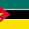
Three equal horizontal bands of green (top), black, and yellow with a red isosceles triangle based on the hoist side; the black band is edged in white; centered in the triangle is a yellow five-pointed star bearing a crossed rifle and hoe in black superimposed on an open white book; green represents the riches of the land, white peace, black the African continent, yellow the country's minerals, and red the struggle for independence; the rifle symbolizes defense and vigilance, the hoe refers to the country's agriculture, the open book stresses the importance of education, and the star represents Marxism and internationalism.

Almost five centuries as a Portuguese colony came to a close with independence in 1975. Large-scale emigration, economic dependence on South Africa, a severe drought, and a prolonged civil war hindered the country's development until the mid-1990s. The ruling Front for the Liberation of Mozambique (FRELIMO) party formally abandoned Marxism in 1989, and a new constitution the following year provided for multiparty elections and a free market economy. A UN-negotiated peace agreement between FRELIMO and rebel Mozambique National Resistance (RENAMO) forces ended the fighting in 1992. In 2004, Mozambique underwent a delicate transition as Joaquim CHISSANO stepped down after 18 years in office. His elected successor, Armando GUEBUZA, served two terms and then passed executive power to Filipe NYUSI in 2014. RENAMO’s residual armed forces have continued to engage in a low-level insurgency since 2012.
Geography
| Area | ||
|---|---|---|
| Total (World Rank: 36) | 799,380 | sq km |
| Land (World Rank: 35) | 786,380 | sq km |
| Water (World Rank: 40) | 13,000 | sq km |
| Forest (World Rank: 20) | 49.60 | % |
| Comparative | slightly more than five times the size of Georgia; slightly less than twice the size of California | |
| Coastline | ||
| 2470 | ||
| Landborder | ||
| 4783 | ||
| Elevation | ||
| Highest point (World Rank: 105) | 2,436 | m |
| Agricultural land | ||
| Total (World Rank: 52) | 56.30 | % |
| Arable (World Rank: 140) | 6.40 | % |
| Permanent crops (World Rank: 163) | 0.30 | % |
| Permanent pastures (World Rank: 20) | 49.60 | % |
| Irrigated land (World Rank: 87) | 1,180 | sq km |
| Map reference | ||
| Africa | ||
| Environment | ||
| Issues |
| |
| Agreement party |
| |
| Hazzards |
| |
| Location | ||
| Southeastern Africa, bordering the Mozambique Channel, between South Africa and Tanzania | ||
| Climate | ||
| tropical to subtropical | ||
| Terrain | ||
| mostly coastal lowlands, uplands in center, high plateaus in northwest, mountains in west | ||
People
| Population | ||
|---|---|---|
| Total (World Rank: 50) | 26,573,700 | |
| Deathrate (World Rank: 25) | 1.16 | % |
| Birthrate (World Rank: 11) | 3.81 | % |
| Growthrate (World Rank: 21) | 2.46 | % |
| Migration rate (World Rank: 125) | -0.19 | % |
| Fertility rate (World Rank: 11) | 5.08 | % |
| Median age | ||
| Male (World Rank: 219) | 16.60 | |
| Female (World Rank: 216) | 17.80 | |
| Age structure | ||
| 0 14 male (World Rank: 30) | 5,975,410 | |
| 0 14 female (World Rank: 29) | 5,908,510 | |
| 15 24 male (World Rank: 41) | 2,824,010 | |
| 15 24 female (World Rank: 39) | 2,907,030 | |
| 25 54 male (World Rank: 61) | 3,409,420 | |
| 25 54 female (World Rank: 58) | 3,875,840 | |
| 55 64 male (World Rank: 78) | 435,203 | |
| 55 64 female (World Rank: 79) | 468,939 | |
| 65 x male (World Rank: 79) | 352,546 | |
| 65 x female (World Rank: 83) | 416,793 | |
| Health | ||
| Infant mortality rate (World Rank: 13) | 6.59 | % |
| Life expectancy total (World Rank: 212) | 54 | years |
| Life expectancy female (World Rank: 213) | 55 | years |
| Life expectancy male (World Rank: 212) | 53 | years |
| Physicians per 1000 (World Rank: 171) | 0.06 | |
| Hospital bed per 1000 (World Rank: 158) | 0.70 | |
| Sanitation access total (World Rank: 192) | 20.50 | % |
| Obesity adult (World Rank: 160) | 7.20 | % |
| Drinking water access (World Rank: 201) | 51.10 | % |
Energy
| Electricity | ||
|---|---|---|
| Production (World Rank: 75) | 19,580,000,000 | kWh |
| Consumption (World Rank: 81) | 13,860,000,000 | kWh |
| Export (World Rank: 17) | 12,880,000,000 | kWh |
| Import (World Rank: 23) | 10,550,000,000 | kWh |
| Source fossil (World Rank: 198) | 14.00 | % |
| Source nuclear (World Rank: 12) | 85.60 | % |
| Source renew (World Rank: 145) | 0.50 | % |
| Refined products | ||
| Consumption (World Rank: 131) | 23,000 | bbl / day |
| Import (World Rank: 113) | 21,890 | bbl / day |
| Natural gas | ||
| Production (World Rank: 49) | 5,695,000,000 | m³ |
| Consumption (World Rank: 79) | 2,726,000,000 | m³ |
| Export (World Rank: 33) | 3,800,000,000 | m³ |
| Carbon footprint | ||
| 3900000 | ||
Nation
| Budget | ||
|---|---|---|
| Education (World Rank: 23) | 7 | % of GDP |
| Military (World Rank: 111) | 1 | % of GDP |
| Health (World Rank: 82) | 7 | % of GDP |
| Surplus (World Rank: 188) | -9 | % of GDP |
| National colours | ||
| yellow | ||
| Adjective | ||
| Mozambican | ||
| Noun | ||
| Mozambican(s) | ||
| Background | ||
| Almost five centuries as a Portuguese colony came to a close with independence in 1975. Large-scale emigration, economic dependence on South Africa, a severe drought, and a prolonged civil war hindered the country's development until the mid-1990s. The ruling Front for the Liberation of Mozambique (FRELIMO) party formally abandoned Marxism in 1989, and a new constitution the following year provided for multiparty elections and a free market economy. A UN-negotiated peace agreement between FRELIMO and rebel Mozambique National Resistance (RENAMO) forces ended the fighting in 1992. In 2004, Mozambique underwent a delicate transition as Joaquim CHISSANO stepped down after 18 years in office. His elected successor, Armando GUEBUZA, served two terms and then passed executive power to Filipe NYUSI in 2014. RENAMO’s residual armed forces have continued to engage in a low-level insurgency since 2012. | ||
| Flag description | ||
| three equal horizontal bands of green (top), black, and yellow with a red isosceles triangle based on the hoist side; the black band is edged in white; centered in the triangle is a yellow five-pointed star bearing a crossed rifle and hoe in black superimposed on an open white book; green represents the riches of the land, white peace, black the African continent, yellow the country's minerals, and red the struggle for independence; the rifle symbolizes defense and vigilance, the hoe refers to the country's agriculture, the open book stresses the importance of education, and the star represents Marxism and internationalism | ||
Economy
| Gdp | ||
|---|---|---|
| Purchasing power parity (World Rank: 123) | 35,080,000,000 | USD |
| Real growth rate (World Rank: 70) | 3.80 | % |
| Per capita purchasing power parity (World Rank: 219) | 1,200 | USD |
| Source agriculture (World Rank: 31) | 24.80 | % |
| Source industry (World Rank: 137) | 21.60 | % |
| Source service (World Rank: 159) | 53.60 | % |
| Labourforce | ||
| Total (World Rank: 44) | 12,500,000 | |
| In poverty (World Rank: 30) | 46.10 | % |
| Products | ||
| Industries |
| |
| Agriculture |
| |
| Exports |
| |
| Imports |
| |
Communication
| Phone | ||
|---|---|---|
| Landline total (World Rank: 144) | 84,310 | |
| Landline per 100 (World Rank: 203) | 1.00 | |
| Mobile per 100 (World Rank: 178) | 71.00 | |
| Assessment | 0 | |
| Internet | ||
| Users (World Rank: 81) | 4,543,280 | |
| Population (World Rank: 194) | 17.50 | % |
Transport
| Air | ||
|---|---|---|
| Airports paved (World Rank: 75) | 21.00 | |
| Airports unpaved (World Rank: 47) | 77.00 | |
| Rail | ||
| Total length (World Rank: 40) | 4,787 | |
| Road | ||
| Total length (World Rank: 96) | 31,083 | |
| Paved length (World Rank: 83) | 7,365 | |
| Unpaved length (World Rank: 60) | 23,718 | |
| Water | ||
| Total length (World Rank: 87) | 460 | |
This is a list of famous places in this country in alphabetical order.
 Aldeia Mala
- Alto Ligonha
- Alto Molocue
- Anchil
- Antonio Enes
- Augusto Sa
- Beira
- Buzi
- Cabaceira Pequena
- Cambulatsitsi
- Cazula
- Chaculane
- Chibuto
- Chidenguele
- Chimoio
- Chinde
- Chokwe
- Cobue
- Cuamba
- Damiao
- David
- Dondo
- Esturro
- G. Massaule
- Gorongosa
- Ibo
- Ibo
- Ilha de Mocambique
- Inhaca
- Inhambane
- Inharrime
- Inhassoro
- Lacticinia
- Lago
- Lagoa Nova
- Lichinga
- Lopes
- Luis
- Lumbo
- Mabiche
- Machipanda
- Machoquene
- Macia
- Malema
- Manhica
- Manica
- Manica
- Manjacaze
- Maputo
- Marracuene
- Marromeu
- Matola
- Matundo
- Maxixe
- Mazimene
- Mecula
- Metangula
- Miceti
- Milalande
- Moatize
- Mocimboa
- Mocimboa da Praia
- Mocuba
- Momade
- Montepuez
- Mucoque
- Mueda
- Mutarara
- Mutuali
- Nacala
- Nacala-a-Velha
- Namaacha
- Nampula
- Nhamatanda
- Nhungo
- Nova Chamba
- Nova Mambone
- Palma
- Pemba
- Ponta d'Ouro
- Praia de Conducia
- Praia do Tofo
- Quelimane
- Quissico
- Regulo Chibamo
- Ressano Garcia
- Santa Carolina
- Sao Martinho
- Sofala
- Tete
- Trigo de Morais
- Vade
- Vila Junqueiro
- Vila Messano
- Vila de Sena
- Vilankulo
- Xai-Xai
- Zavora
- Zolala
- Zumbo