Kazakhstan
in Central Asia
Asia
 China
China Kyrgyzstan
 Russia
 Turkmenistan
 Uzbekistan
- Currency and Currency Code:
- Tenge - KZT
- Spoken languages:
- Kazakh, Russian
- Local electricity:
- 220 V - 50 Hz (plugs: C, F)
- Mobile phone / cellular frequencies (MHz):
- 900 MHz, 3G, 4G
- ISO 2-Letter code:
- KZ
- Internet top level domain:
- .kz
- Country phone prefix:
- +7
- Local Time (capital):
- Timezone:
- UTC/GMT offset: hours
Safety Score: 3,0 of 5.0 based on data from 9 authorites. Meaning we advice caution when travelling to Kazakhstan.
Travel warnings are updated daily. Source: Travel Warning Kazakhstan. Last Update: 2024-04-25 08:17:04
Explore Kazakhstan
Kazakhstan with its capital Astana is located in Asia (Central Asia, northwest of China; a small portion west of the Ural (Zhayyq) River in easternmost Europe). It covers some 2,724,901 square kilometers (slightly less than four times the size of Texas) with a population of 18,556,700. Kazakh and Russian are the languages spoken by people in Kazakhstan. China, Kyrgyzstan, Russia, Turkmenistan and Uzbekistan are bordering countries.
Kazakhstan is by far the largest of the Central Asian states of the former Soviet Union. Since its cold and windy weather conditions visiting saunas with friends is very popular in Kazakhstan. Saunas (Russian banyas or Finnish steam rooms) are an excellent place to discuss business issues or just socialize with friends. Having parties (birthdays, New Year, etc) in saunas is a normal practice.
Popular Destinations in Kazakhstan
Administrative regions of Kazakhstan
- Aktyubinskaya Oblast'
- Almaty Oblysy
- Almaty Qalasy
- Aqmola Oblysy
- Astana Qalasy
- Atyrau Oblysy
- Baikonur
- East Kazakhstan
- Mangistauskaya Oblast'
- North Kazakhstan
- Pavlodar Oblysy
- Qaraghandy Oblysy
- Qostanay Oblysy
- Qyzylorda Oblysy
- South Kazakhstan
- West Kazakhstan
- Zhambyl Oblysy
About the country
The topography is vast flat steppe extending from the Volga in the west to the Altai Mountains in the east and from the plains of western Siberia in the north to oases and deserts of Central Asia in the south. The average density of population is about 7 per km². The climate in Kazakhstan can be described as continental, cold winters and hot summers, arid and semiarid. Potential natural disasters are earthquakes in the south mudslides around Almaty
To reach someone Kazakhstan dial +7 prior to a number. The local cellular networks are operated on 900 MHz, 3G, 4G. Websites typically end with the top level domain ".kz". If you want to bring electric appliances (e.g. battery chaarger), keep in min the local 220 V - 50 Hz (plugs: C, F). The sign for the locally used currency Tenge is KZT.
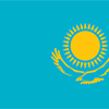
A gold sun with 32 rays above a soaring golden steppe eagle, both centered on a sky blue background; the hoist side displays a national ornamental pattern "koshkar-muiz" (the horns of the ram) in gold; the blue color is of religious significance to the Turkic peoples of the country, and so symbolizes cultural and ethnic unity; it also represents the endless sky as well as water; the sun, a source of life and energy, exemplifies wealth and plenitude; the sun's rays are shaped like grain, which is the basis of abundance and prosperity; the eagle has appeared on the flags of Kazakh tribes for centuries and represents freedom, power, and the flight to the future.

Ethnic Kazakhs, a mix of Turkic and Mongol nomadic tribes who migrated to the region by the 13th century, were rarely united as a single nation. The area was conquered by Russia in the 18th century, and Kazakhstan became a Soviet Republic in 1936. Soviet policies reduced the number of ethnic Kazakhs in the 1930s and enabled non-ethnic Kazakhs to outnumber natives. During the 1950s and 1960s agricultural "Virgin Lands" program, Soviet citizens were encouraged to help cultivate Kazakhstan's northern pastures. This influx of immigrants (mostly Russians, but also some other deported nationalities) further skewed the ethnic mixture. Non-Muslim ethnic minorities departed Kazakhstan in large numbers from the mid-1990s through the mid-2000s and a national program has repatriated about a million ethnic Kazakhs back to Kazakhstan. These trends have allowed Kazakhs to become the titular majority again. This dramatic demographic shift has also undermined the previous religious diversity and made the country more than 70% Muslim. Kazakhstan's economy is larger than those of all the other Central Asian states largely due to the country's vast natural resources. Current issues include: developing a cohesive national identity, expanding the development of the country's vast energy resources and exporting them to world markets, diversifying the economy, enhancing Kazakhstan's economic competitiveness, and strengthening relations with neighboring states and foreign powers.
Geography
| Area | ||
|---|---|---|
| Total (World Rank: 10) | 2,724,900 | sq km |
| Land (World Rank: 10) | 2,699,700 | sq km |
| Water (World Rank: 21) | 25,200 | sq km |
| Forest (World Rank: 12) | 68.50 | % |
| Comparative | slightly less than four times the size of Texas | |
| Landborder | ||
| 13364 | ||
| Elevation | ||
| Lowest point (World Rank: 68) | -132 | m |
| Highest point (World Rank: 9) | 6,995 | m |
| Agricultural land | ||
| Total (World Rank: 9) | 77.40 | % |
| Arable (World Rank: 122) | 8.90 | % |
| Permanent pastures (World Rank: 12) | 68.50 | % |
| Irrigated land (World Rank: 28) | 20,660 | sq km |
| Map reference | ||
| Asia | ||
| Environment | ||
| Issues |
| |
| Agreement party |
| |
| Agreement signed | Climate Change-Kyoto Protocol | |
| Hazzards |
| |
| Location | ||
| Central Asia, northwest of China; a small portion west of the Ural (Zhayyq) River in easternmost Europe | ||
| Climate | ||
| continental, cold winters and hot summers, arid and semiarid | ||
| Terrain | ||
| vast flat steppe extending from the Volga in the west to the Altai Mountains in the east and from the plains of western Siberia in the north to oases and deserts of Central Asia in the south | ||
People
| Population | ||
|---|---|---|
| Total (World Rank: 62) | 18,556,700 | |
| Deathrate (World Rank: 88) | 0.81 | % |
| Birthrate (World Rank: 96) | 1.81 | % |
| Growthrate (World Rank: 107) | 1.04 | % |
| Migration rate (World Rank: 62) | 0.04 | % |
| Fertility rate (World Rank: 93) | 2.25 | % |
| Median age | ||
| Male (World Rank: 117) | 29.30 | |
| Female (World Rank: 103) | 31.90 | |
| Age structure | ||
| 0 14 male (World Rank: 73) | 2,374,430 | |
| 0 14 female (World Rank: 71) | 2,434,210 | |
| 15 24 male (World Rank: 71) | 1,329,380 | |
| 15 24 female (World Rank: 71) | 1,277,620 | |
| 25 54 male (World Rank: 58) | 3,847,280 | |
| 25 54 female (World Rank: 57) | 4,024,050 | |
| 55 64 male (World Rank: 50) | 810,019 | |
| 55 64 female (World Rank: 46) | 1,040,920 | |
| 65 x male (World Rank: 67) | 494,064 | |
| 65 x female (World Rank: 54) | 924,734 | |
| Health | ||
| Infant mortality rate (World Rank: 81) | 1.96 | % |
| Life expectancy total (World Rank: 149) | 71 | years |
| Life expectancy female (World Rank: 133) | 76 | years |
| Life expectancy male (World Rank: 162) | 66 | years |
| Physicians per 1000 (World Rank: 33) | 3.27 | |
| Hospital bed per 1000 (World Rank: 12) | 7.20 | |
| Sanitation access total (World Rank: 55) | 97.50 | % |
| Obesity adult (World Rank: 94) | 21.00 | % |
| Drinking water access (World Rank: 125) | 92.90 | % |
Energy
| Electricity | ||
|---|---|---|
| Production (World Rank: 35) | 100,400,000,000 | kWh |
| Consumption (World Rank: 33) | 95,260,000,000 | kWh |
| Export (World Rank: 46) | 1,614,000,000 | kWh |
| Import (World Rank: 57) | 1,618,000,000 | kWh |
| Source fossil (World Rank: 76) | 86.10 | % |
| Source nuclear (World Rank: 107) | 13.30 | % |
| Source renew (World Rank: 140) | 0.80 | % |
| Crude oil | ||
| Production (World Rank: 16) | 1,595,000 | bbl / day |
| Exports (World Rank: 13) | 1,292,000 | bbl / day |
| Imports (World Rank: 37) | 145,800 | bbl / day |
| Proved reserves (World Rank: 12) | 30,000,000,000 | bbl |
| Refined products | ||
| Production (World Rank: 46) | 228,600 | bbl / day |
| Consumption (World Rank: 56) | 186,300 | bbl / day |
| Export (World Rank: 107) | 846 | bbl / day |
| Import (World Rank: 87) | 44,490 | bbl / day |
| Natural gas | ||
| Production (World Rank: 29) | 21,380,000,000 | m³ |
| Consumption (World Rank: 49) | 13,100,000,000 | m³ |
| Export (World Rank: 19) | 13,700,000,000 | m³ |
| Import (World Rank: 14) | 0 | m³ |
| Carbon footprint | ||
| 257800000 | ||
Nation
| Budget | ||
|---|---|---|
| Education (World Rank: 134) | 3 | % of GDP |
| Military (World Rank: 128) | 1 | % of GDP |
| Health (World Rank: 157) | 4 | % of GDP |
| Surplus (World Rank: 47) | -0 | % of GDP |
| National symbol | ||
| golden eagle | ||
| National colours | ||
| yellow | ||
| Adjective | ||
| Kazakhstani | ||
| Noun | ||
| Kazakhstani(s) | ||
| Background | ||
| Ethnic Kazakhs, a mix of Turkic and Mongol nomadic tribes who migrated to the region by the 13th century, were rarely united as a single nation. The area was conquered by Russia in the 18th century, and Kazakhstan became a Soviet Republic in 1936. Soviet policies reduced the number of ethnic Kazakhs in the 1930s and enabled non-ethnic Kazakhs to outnumber natives. During the 1950s and 1960s agricultural "Virgin Lands" program, Soviet citizens were encouraged to help cultivate Kazakhstan's northern pastures. This influx of immigrants (mostly Russians, but also some other deported nationalities) further skewed the ethnic mixture. Non-Muslim ethnic minorities departed Kazakhstan in large numbers from the mid-1990s through the mid-2000s and a national program has repatriated about a million ethnic Kazakhs back to Kazakhstan. These trends have allowed Kazakhs to become the titular majority again. This dramatic demographic shift has also undermined the previous religious diversity and made the country more than 70% Muslim. Kazakhstan's economy is larger than those of all the other Central Asian states largely due to the country's vast natural resources. Current issues include: developing a cohesive national identity, expanding the development of the country's vast energy resources and exporting them to world markets, diversifying the economy, enhancing Kazakhstan's economic competitiveness, and strengthening relations with neighboring states and foreign powers. | ||
| Flag description | ||
| a gold sun with 32 rays above a soaring golden steppe eagle, both centered on a sky blue background; the hoist side displays a national ornamental pattern "koshkar-muiz" (the horns of the ram) in gold; the blue color is of religious significance to the Turkic peoples of the country, and so symbolizes cultural and ethnic unity; it also represents the endless sky as well as water; the sun, a source of life and energy, exemplifies wealth and plenitude; the sun's rays are shaped like grain, which is the basis of abundance and prosperity; the eagle has appeared on the flags of Kazakh tribes for centuries and represents freedom, power, and the flight to the future | ||
Economy
| Gdp | ||
|---|---|---|
| Purchasing power parity (World Rank: 41) | 451,200,000,000 | USD |
| Real growth rate (World Rank: 168) | 1.10 | % |
| Per capita purchasing power parity (World Rank: 75) | 25,200 | USD |
| Source agriculture (World Rank: 128) | 4.80 | % |
| Source industry (World Rank: 51) | 33.90 | % |
| Source service (World Rank: 111) | 61.30 | % |
| Labourforce | ||
| Total (World Rank: 53) | 8,999,000 | |
| In poverty (World Rank: 168) | 2.70 | % |
| Products | ||
| Industries |
| |
| Agriculture |
| |
| Exports |
| |
| Imports |
| |
Communication
| Phone | ||
|---|---|---|
| Landline total (World Rank: 37) | 3,931,100 | |
| Landline per 100 (World Rank: 81) | 21.00 | |
| Mobile per 100 (World Rank: 43) | 138.00 | |
| Assessment | 0 | |
| Internet | ||
| Users (World Rank: 40) | 14,100,800 | |
| Population (World Rank: 56) | 76.80 | % |
Transport
| Air | ||
|---|---|---|
| Airports paved (World Rank: 40) | 63.00 | |
| Airports unpaved (World Rank: 79) | 33.00 | |
| Heliports (World Rank: 43) | 3.00 | |
| Rail | ||
| Total length (World Rank: 19) | 14,184 | |
| Road | ||
| Total length (World Rank: 48) | 97,418 | |
| Paved length (World Rank: 31) | 87,140 | |
| Unpaved length (World Rank: 85) | 10,278 | |
| Water | ||
| Total length (World Rank: 26) | 4,000 | |
This is a list of famous places in this country in alphabetical order.
 Abay
Abay- Aksu
- Aktau
- Almaty
- Aqkoel
- Aqsay
- Aqtobe
- Aral
- Arkalyk
- Arys
- Astana
- Astrakhan
- Atakent
- Atbasar
- Atyrau
- Ayagoz
- Ayteke Bi
- Baikonur
- Balqash
- Balyqshy
- Batamshinskiy
- Belousovka
- Belyye Vody
- Bulayevo
- Burunday
- Chardara
- Chu
- Dzhetygara
- Ekibastuz
- Esik
- Georgiyevka
- Glubokoye
- Irtyshsk
- Kandyagash
- Kapshagay
- Karagandy
- Karatau
- Kentau
- Khromtau
- Kokshetau
- Kostanay
- Kurchatov
- Kurchum
- Kyzyl-Orda
- Kyzylorda
- Kzyltu
- Lenger
- Leninskiy
- Lisakovsk
- Lugovoye
- Makinsk
- Martuk
- Merke
- Oral
- Ordzhonikidze
- Otegen Batyra
- Pavlodar
- Petropavl
- Qarazhal
- Qarqaraly
- Qashar
- Qashyr
- Qulsary
- Ridder
- Rudnyy
- Sarkand
- Saryaghash
- Semey
- Sergeyevka
- Shakhan
- Shantobe
- Shchuchinsk
- Shemonaikha
- Shieli
- Shymkent
- Soran
- Stepnogorsk
- Stepnyak
- Taldykorgan
- Taldyqorghan
- Talghar
- Taraz
- Temirtau
- Torghay
- Urzhar
- Ush-Tyube
- Ust-Kamenogorsk
- Vannovka
- Yanykurgan
- Yeraliyev
- Yermentau
- Zaysan
- Zhanaozen
- Zhangatas
- Zhanibek
- Zharkent
- Zhelezinka
- Zhezqazghan
- Zhosaly
- Zyryanovsk