Guam
in Micronesia
Oceania
- Currency and Currency Code:
- Dollar - USD
- Spoken languages:
- English, Chamorro
- Local electricity:
- 110 V - 60 Hz (plugs: A, B)
- Mobile phone / cellular frequencies (MHz):
- 850 MHz, 1900 MHz, 3G, 4G
- ISO 2-Letter code:
- GU
- Internet top level domain:
- .gu
- Country phone prefix:
- +1-671
- Local Time (capital):
- Timezone:
- UTC/GMT offset: hours
Safety Score: 4,0 of 5.0 based on data from 9 authorites. Meaning please reconsider your need to travel to Guam.
Travel warnings are updated daily. Source: Travel Warning Guam. Last Update: 2024-08-13 08:21:03
Explore Guam
Guam with its capital Hagatna is located in Oceania (Oceania, island in the North Pacific Ocean). It covers some 545 square kilometers (three times the size of Washington, DC) with 167,358 citizens. English and Chamorro are the common languages used in Guam. This country shares no land borders with another country.
Guam is an island in the western South Pacific Ocean, about three-quarters of the way from Hawaii to the Philippines. It is the largest and southernmost island in the Mariana Islands archipelago. Guam is a territory of the United States of America. It is considered to occupy a militarily strategic location, south of the Commonwealth of the Northern Mariana Islands.
Popular Destinations in Guam
Administrative regions of Guam
- Agana Heights
- Agat
- Asan
- Barrigada
- Chalan Pago-Ordot Municipality
- Dededo
- Hagatna
- Inarajan
- Mangilao
- Merizo Municipality
- Mongmong-Toto-Maite Municipality
- Piti Municipality
- Santa Rita Municipality
- Sinajana Municipality
- Talofofo Municipality
- Tamuning
- Umatac
- Yigo Municipality
- Yona
About the country
The landscape is volcanic origin, surrounded by coral reefs and relatively flat coralline limestone plateau (source of most fresh water), with steep coastal cliffs and narrow coastal plains in north, low hills in center, mountains in south. The average density of population is about 308 per km². The climate in Guam can be described as tropical marinegenerally warm and humid, moderated by northeast trade winds, dry season (January to June), rainy season (July to December), little seasonal temperature variation. Potential threats by nature are frequent squalls during rainy season relatively rare but potentially destructive typhoons (June to December)
To reach someone Guam dial +1-671 prior to a number. The local cellular networks are operated on 850 MHz, 1900 MHz, 3G, 4G. Websites typically end with the top level domain ".gu". If you want to bring electric appliances (e.g. battery chaarger), keep in min the local 110 V - 60 Hz (plugs: A, B). The sign for the locally used currency Dollar is USD.
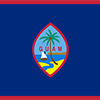
Territorial flag is dark blue with a narrow red border on all four sides; centered is a red-bordered, pointed, vertical ellipse containing a beach scene, a proa or outrigger canoe with sail, and a palm tree with the word GUAM superimposed in bold red letters; the proa is sailing in Agana Bay with the promontory of Punta Dos Amantes, near the capital, in the background; the shape of the central emblem is that of a Chamorro sling stone, used as a weapon for defense or hunting; blue represents the sea and red the blood shed in the struggle against oppression.

Spain ceded Guam to the US in 1898. Captured by the Japanese in 1941, it was retaken by the US three years later. The military installations on the island are some of the most strategically important US bases in the Pacific.
Geography
| Area | ||
|---|---|---|
| Total (World Rank: 195) | 544 | sq km |
| Land (World Rank: 192) | 544 | sq km |
| Forest (World Rank: 113) | 14.80 | % |
| Comparative | three times the size of Washington, DC | |
| Coastline | ||
| 125.5 | ||
| Elevation | ||
| Highest point (World Rank: 198) | 406 | m |
| Agricultural land | ||
| Total (World Rank: 125) | 33.40 | % |
| Arable (World Rank: 185) | 1.90 | % |
| Permanent crops (World Rank: 14) | 16.70 | % |
| Permanent pastures (World Rank: 113) | 14.80 | % |
| Irrigated land (World Rank: 176) | 2 | sq km |
| Map reference | ||
| Oceania | ||
| Environment | ||
| Issues |
| |
| Hazzards |
| |
| Location | ||
| Oceania, island in the North Pacific Ocean, about three-quarters of the way from Hawaii to the Philippines | ||
| Climate | ||
| tropical marine; generally warm and humid, moderated by northeast trade winds; dry season (January to June), rainy season (July to December); little seasonal temperature variation | ||
| Terrain | ||
| volcanic origin, surrounded by coral reefs; relatively flat coralline limestone plateau (source of most fresh water), with steep coastal cliffs and narrow coastal plains in north, low hills in center, mountains in south | ||
People
| Population | ||
|---|---|---|
| Total (World Rank: 185) | 167,358 | |
| Deathrate (World Rank: 162) | 0.60 | % |
| Birthrate (World Rank: 80) | 1.97 | % |
| Growthrate (World Rank: 175) | 0.26 | % |
| Migration rate (World Rank: 177) | -1.11 | % |
| Fertility rate (World Rank: 56) | 2.96 | % |
| Median age | ||
| Male (World Rank: 125) | 28.30 | |
| Female (World Rank: 116) | 29.70 | |
| Age structure | ||
| 0 14 male (World Rank: 185) | 23,896 | |
| 0 14 female (World Rank: 185) | 22,190 | |
| 15 24 male (World Rank: 185) | 14,847 | |
| 15 24 female (World Rank: 185) | 12,981 | |
| 25 54 male (World Rank: 185) | 32,295 | |
| 25 54 female (World Rank: 186) | 30,356 | |
| 55 64 male (World Rank: 182) | 8,352 | |
| 55 64 female (World Rank: 184) | 8,057 | |
| 65 x male (World Rank: 186) | 6,706 | |
| 65 x female (World Rank: 186) | 7,678 | |
| Health | ||
| Infant mortality rate (World Rank: 113) | 1.26 | % |
| Life expectancy total (World Rank: 91) | 76 | years |
| Life expectancy female (World Rank: 97) | 79 | years |
| Life expectancy male (World Rank: 88) | 74 | years |
| Physicians per 1000 (World Rank: 118) | 0.84 | |
| Sanitation access total (World Rank: 100) | 89.80 | % |
| Drinking water access (World Rank: 56) | 99.50 | % |
Energy
| Electricity | ||
|---|---|---|
| Production (World Rank: 142) | 1,623,000,000 | kWh |
| Consumption (World Rank: 147) | 1,509,000,000 | kWh |
| Source fossil (World Rank: 5) | 100.00 | % |
| Refined products | ||
| Consumption (World Rank: 148) | 15,400 | bbl / day |
| Import (World Rank: 130) | 15,230 | bbl / day |
| Carbon footprint | ||
| 1800000 | ||
Economy
| Gdp | ||
|---|---|---|
| Purchasing power parity (World Rank: 176) | 4,882,000,000 | USD |
| Real growth rate (World Rank: 180) | 0.60 | % |
| Per capita purchasing power parity (World Rank: 60) | 30,500 | USD |
| Labourforce | ||
| Total (World Rank: 183) | 70,490 | |
| In poverty (World Rank: 85) | 23.00 | % |
| Products | ||
| Industries |
| |
| Agriculture |
| |
| Exports |
| |
| Imports |
| |
Nation
| Budget | ||
|---|---|---|
| Surplus (World Rank: 60) | -1 | % of GDP |
| National symbol | ||
| coconut tree | ||
| National colours | ||
| red | ||
| Adjective | ||
| Guamanian | ||
| Noun | ||
| Guamanian(s) (US citizens) | ||
| Background | ||
| Spain ceded Guam to the US in 1898. Captured by the Japanese in 1941, it was retaken by the US three years later. The military installations on the island are some of the most strategically important US bases in the Pacific. | ||
| Flag description | ||
| territorial flag is dark blue with a narrow red border on all four sides; centered is a red-bordered, pointed, vertical ellipse containing a beach scene, a proa or outrigger canoe with sail, and a palm tree with the word GUAM superimposed in bold red letters; the proa is sailing in Agana Bay with the promontory of Punta Dos Amantes, near the capital, in the background; the shape of the central emblem is that of a Chamorro sling stone, used as a weapon for defense or hunting; blue represents the sea and red the blood shed in the struggle against oppression | ||
Communication
| Phone | ||
|---|---|---|
| Landline total (World Rank: 149) | 68,000 | |
| Landline per 100 (World Rank: 33) | 42.00 | |
| Mobile per 100 (World Rank: 96) | 113.00 | |
| Assessment | 0 | |
| Internet | ||
| Users (World Rank: 172) | 125,328 | |
| Population (World Rank: 55) | 77.00 | % |
Transport
| Air | ||
|---|---|---|
| Airports paved (World Rank: 160) | 4.00 | |
| Airports unpaved (World Rank: 188) | 1.00 | |
| Road | ||
| Total length (World Rank: 186) | 1,045 | |
This is a list of famous places in this country in alphabetical order.
 Agana Heights Village
- Agat Village
- Asan-Maina Village
- Barrigada Village
- Chalan Pago-Ordot Village
- Dededo Village
- Guam Government House
- Hagatna
- Hagatna Village
- Inarajan Village
- Mangilao Village
- Merizo Village
- Mongmong-Toto-Maite Village
- Piti Village
- Santa Rita
- Sinajana Village
- Talofofo Village
- Tamuning-Tumon-Harmon Village
- Umatac Village
- Yigo Village
- Yona Village