
Facts and Data
Webpages:
Official Unesco Page
Basis Data:
Unesco World heritage since: 2013
Size of heritage: 16,603 ha
- Buffer zone: 29,501 ha
Coordinates:
Longitude: 102,780°
Latitude: 23,093°
Summary
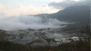
The Cultural Landscape of Honghe Hani Rice Terraces, China covers 16,603-hectares in Southern Yunnan. It is marked by spectacular terraces that cascade down the slopes of the towering Ailao Mountains to the banks of the Hong River. Over the past 1,300 years, the Hani people have developed a complex system of channels to bring water from the forested mountaintops to the terraces. They have also created an integrated farming system that involves buffalos, cattle, ducks, fish and eel and supports the production of red rice, the area’s primary crop. The inhabitants worship the sun, moon, mountains, rivers, forests and other natural phenomena including fire. They live in 82 villages situated between the mountaintop forests and the terraces. The villages feature traditional thatched “mushroom” houses. The resilient land management system of the rice terraces demonstrates extraordinary harmony between people and their environment, both visually and ecologically, based on exceptional and long-standing social and religious structures.
Location on Map
Show bigger map on Openstreetmap
Introduction
The Cultural Landscape of Honghe Hani Rice Terraces, located in southern Yunnan Province, China, is a UNESCO World Heritage site renowned for its breathtaking beauty and unique agricultural practices. This cultural landscape encompasses over 16,000 hectares of terraced rice fields, stretching across the Honghe River basin. The site is not only a testament to the ingenuity and sustainable farming techniques of the Hani people but also a living example of their harmonious coexistence with nature.History
The history of the Honghe Hani Rice Terraces dates back over 1,300 years when the Hani people migrated to this mountainous region. Faced with the challenge of cultivating crops on steep slopes, they ingeniously developed a sophisticated system of terraces that allowed them to grow rice and other crops. The construction of these terraces involved extensive manual labor, with each terrace carefully carved into the mountainside and supported by an intricate network of irrigation channels. Over the centuries, the Hani people refined their agricultural techniques, passing down their knowledge from one generation to the next. The rice terraces became not only a means of sustenance but also a symbol of their cultural identity and a source of pride. The Hani people's deep respect for nature is reflected in their sustainable farming practices, which prioritize water conservation and soil preservation.Current State
Today, the Cultural Landscape of Honghe Hani Rice Terraces remains a vibrant and living testament to the Hani people's agricultural heritage. The terraces are still actively cultivated by the local communities, who continue to practice traditional farming methods. The Hani people's intimate knowledge of the land and their sustainable practices have allowed them to maintain the terraces' productivity while preserving the ecological balance of the region. The rice terraces are not only a source of food but also a source of income for the Hani people. The unique beauty of the landscape has attracted tourists from around the world, providing opportunities for cultural exchange and economic development. However, the increasing number of visitors also poses challenges in terms of managing tourism sustainably and preserving the integrity of the site. Efforts have been made to strike a balance between tourism and conservation. Local authorities, in collaboration with UNESCO, have implemented measures to protect the terraces and promote sustainable tourism practices. These include the establishment of visitor centers, the development of eco-friendly accommodations, and the implementation of regulations to control visitor numbers and behavior. The Cultural Landscape of Honghe Hani Rice Terraces is not only a remarkable example of human ingenuity but also a living cultural landscape that reflects the deep connection between the Hani people and their environment. It serves as a reminder of the importance of sustainable practices and the need to preserve our natural and cultural heritage for future generations.Videos from the area

元陽・多依樹の棚田 Rice Fields Duoyishu Yuanyang China
見ての通りです。が朝焼け、日の入りは見られませんでした。がイ族のたまご売りが買ってよ買ってよとやってきました。が2007年1月14...
Postcard without Word - Terrace Rice Fields in Yuanyang China
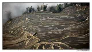
Mountain mist embraces the terrace rice fields in Yuanyang, China.
Postcard without Word - Terrace Rice Fields in Yuanyang China (2)
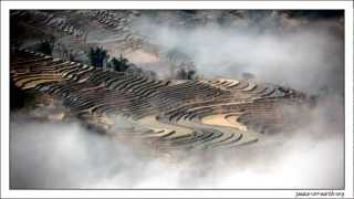
Mountain mist embraces the terrace rice fields in Yuanyang, China.
Videos provided by Youtube are under the copyright of their owners. 
 Bounneau Airport
Small airport - 115 mi (185 km)
 Dien Bien Phu Airport
Medium airport - 118 mi (191 km)
 Simao Airport
Small airport - 118 mi (190 km)
Kunming Wujiaba International AirportLarge airport - 131 mi (212 km)
Xishuangbanna Gasa AirportMedium airport - 150 mi (242 km)
Na-San AirportSmall airport - 152 mi (246 km)
Luang Namtha AirportSmall airport - 171 mi (276 km)
Oudomsay AirportSmall airport - 174 mi (281 km)
Noi Bai International AirportLarge airport - 233 mi (375 km)
Longdongbao AirportLarge airport - 347 mi (558 km)
Bigger and popular cities in the wider vicinity are these:
- Baigecun
- Daxing
- Gejiu
- Hexi
- Huaxijie
- Jinhe
- Jiujie
- Jiujie
- Lai Chau
- Lijiang
- Lin'an
- Lishan
- Longwu
- Menglie
- Muong Nhe
- Najiaying
- Nansha
- Ningzhou
- Panjiang
- Phong Tho
- Sijie
- Thi Tran Muong Te
- Thi Tran Sin Ho
- Wenlan
- Xiaojie
- Xiushan
- Yangguang
- Yilong
- Yisa
- Yuping
These are some smaller cities that might be interesting. They are all rather close.