Brunei
in
Asia
 Malaysia
- Currency and Currency Code:
- Dollar - BND
- Spoken languages:
- Malay, English
- Local electricity:
- 240 V - 50 Hz (plugs: G)
- Mobile phone / cellular frequencies (MHz):
- 900 MHz, 3G, 4G
- ISO 2-Letter code:
- BN
- Internet top level domain:
- .bn
- Country phone prefix:
- +673
- Local Time (capital):
- Timezone:
- UTC/GMT offset: hours
Safety Score: 3,0 of 5.0 based on data from 9 authorites. Meaning we advice caution when travelling to Brunei.
Travel warnings are updated daily. Source: Travel Warning Brunei. Last Update: 2024-04-26 08:02:42
Explore Brunei
Brunei with its capital Bandar Seri Begawan is located in Asia (Southeastern Asia, along the northern coast of the island of Borneo). It covers some 5,766 square kilometers (slightly smaller than Delaware) with a population of 443,593. Malay and English are the languages spoken by people in Brunei. Did you know that Malaysia is the only bordering country.
The Sultanate of Brunei is a small but rich country located in Southeast Asia. Brunei is officially an Islamic state, with many large beautiful mosques across the country. Sale of alcohol is banned. Bringing in meat, (other than seafood) which has not been certified halal, (slaughtered according to Islamic law), is also banned. During the fasting month of Ramadan, many shops and restaurants will be open. Brunei's climate is semi-tropical, and Bandar Seri Begawan's is sub-tropical. The temperature ranges from 14°C to 33°C - January being the hottest month. There are no typhoons, earthquakes, severe flooding and other forms of natural disasters to contend with, and the biggest environmental issues is the seasonal haze resulting from forest fires (that is caused by illegal clearing of land) in nearby Indonesia. Nationals of Israel are not allowed to enter Brunei, though other passports containing Israeli stamps and visas are not a problem for entry.
Popular Destinations in Brunei
Administrative regions of Brunei
About the country
The terrain is flat coastal plain rises to mountains in east having hilly lowland in west. The average density of population is about 77 per km². The climate in Brunei can be described as tropical with hot, humid, rainy. Possible natural disasters include typhoons, earthquakes, and severe flooding are rare.
To reach someone Brunei dial +673 prior to a number. The local cellular networks are operated on 900 MHz, 3G, 4G. Websites typically end with the top level domain ".bn". If you want to bring electric appliances (e.g. battery chaarger), keep in min the local 240 V - 50 Hz (plugs: G). The sign for the locally used currency Dollar is BND.
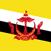
Yellow with two diagonal bands of white (top, almost double width) and black starting from the upper hoist side; the national emblem in red is superimposed at the center; yellow is the color of royalty and symbolizes the sultanate; the white and black bands denote Brunei's chief ministers; the emblem includes five main components: a swallow-tailed flag, the royal umbrella representing the monarchy, the wings of four feathers symbolizing justice, tranquility, prosperity, and peace, the two upraised hands signifying the government's pledge to preserve and promote the welfare of the people, and the crescent moon denoting Islam, the state religion; the state motto "Always render service with God's guidance" appears in yellow Arabic script on the crescent; a ribbon below the crescent reads "Brunei, the Abode of Peace".

The Sultanate of Brunei's influence peaked between the 15th and 17th centuries when its control extended over coastal areas of northwest Borneo and the southern Philippines. Brunei subsequently entered a period of decline brought on by internal strife over royal succession, colonial expansion of European powers, and piracy. In 1888, Brunei became a British protectorate; independence was achieved in 1984. The same family has ruled Brunei for over six centuries. Brunei benefits from extensive petroleum and natural gas fields, the source of one of the highest per capita GDPs in the world.
Geography
| Area | ||
|---|---|---|
| Total (World Rank: 173) | 5,765 | sq km |
| Land (World Rank: 171) | 5,265 | sq km |
| Water (World Rank: 120) | 500 | sq km |
| Forest (World Rank: 191) | 0.60 | % |
| Comparative | slightly smaller than Delaware | |
| Coastline | ||
| 161 | ||
| Landborder | ||
| 266 | ||
| Elevation | ||
| Highest point (World Rank: 134) | 1,850 | m |
| Agricultural land | ||
| Total (World Rank: 216) | 2.50 | % |
| Arable (World Rank: 200) | 0.80 | % |
| Permanent crops (World Rank: 120) | 1.10 | % |
| Permanent pastures (World Rank: 191) | 0.60 | % |
| Irrigated land (World Rank: 167) | 10 | sq km |
| Map reference | ||
| Southeast Asia | ||
| Environment | ||
| Issues | seasonal smoke/haze resulting from forest fires in Indonesia | |
| Agreement party |
| |
| Hazzards | typhoons, earthquakes, and severe flooding are rare | |
| Location | ||
| Southeastern Asia, along the northern coast of the island of Borneo, bordering the South China Sea and Malaysia | ||
| Climate | ||
| tropical; hot, humid, rainy | ||
| Terrain | ||
| flat coastal plain rises to mountains in east; hilly lowland in west | ||
People
| Population | ||
|---|---|---|
| Total (World Rank: 173) | 443,593 | |
| Deathrate (World Rank: 213) | 0.36 | % |
| Birthrate (World Rank: 107) | 1.70 | % |
| Growthrate (World Rank: 70) | 1.57 | % |
| Migration rate (World Rank: 38) | 0.24 | % |
| Fertility rate (World Rank: 151) | 1.78 | % |
| Median age | ||
| Male (World Rank: 113) | 29.70 | |
| Female (World Rank: 111) | 30.70 | |
| Age structure | ||
| 0 14 male (World Rank: 171) | 52,862 | |
| 0 14 female (World Rank: 171) | 49,717 | |
| 15 24 male (World Rank: 172) | 37,637 | |
| 15 24 female (World Rank: 170) | 38,005 | |
| 25 54 male (World Rank: 174) | 99,203 | |
| 25 54 female (World Rank: 172) | 108,198 | |
| 55 64 male (World Rank: 170) | 18,537 | |
| 55 64 female (World Rank: 174) | 17,974 | |
| 65 x male (World Rank: 177) | 10,440 | |
| 65 x female (World Rank: 178) | 11,020 | |
| Health | ||
| Infant mortality rate (World Rank: 139) | 0.96 | % |
| Life expectancy total (World Rank: 73) | 77 | years |
| Life expectancy female (World Rank: 79) | 80 | years |
| Life expectancy male (World Rank: 67) | 75 | years |
| Physicians per 1000 (World Rank: 97) | 1.47 | |
| Hospital bed per 1000 (World Rank: 79) | 2.80 | |
| Obesity adult (World Rank: 129) | 14.10 | % |
Energy
| Electricity | ||
|---|---|---|
| Production (World Rank: 124) | 3,948,000,000 | kWh |
| Consumption (World Rank: 130) | 3,679,000,000 | kWh |
| Source fossil (World Rank: 26) | 99.90 | % |
| Source renew (World Rank: 161) | 0.10 | % |
| Crude oil | ||
| Production (World Rank: 41) | 109,100 | bbl / day |
| Exports (World Rank: 35) | 119,500 | bbl / day |
| Imports (World Rank: 83) | 160 | bbl / day |
| Proved reserves (World Rank: 41) | 1,100,000,000 | bbl |
| Refined products | ||
| Production (World Rank: 100) | 8,345 | bbl / day |
| Consumption (World Rank: 142) | 18,000 | bbl / day |
| Export (World Rank: 113) | 314 | bbl / day |
| Import (World Rank: 144) | 8,313 | bbl / day |
| Natural gas | ||
| Production (World Rank: 37) | 12,000,000,000 | m³ |
| Consumption (World Rank: 67) | 4,545,000,000 | m³ |
| Export (World Rank: 23) | 8,520,000,000 | m³ |
| Carbon footprint | ||
| 8400000 | ||
Nation
| Budget | ||
|---|---|---|
| Education (World Rank: 117) | 4 | % of GDP |
| Military (World Rank: 22) | 4 | % of GDP |
| Health (World Rank: 187) | 3 | % of GDP |
| Surplus (World Rank: 206) | -17 | % of GDP |
| National symbol | ||
| royal parasol | ||
| National colours | ||
| yellow | ||
| Adjective | ||
| Bruneian | ||
| Noun | ||
| Bruneian(s) | ||
| Background | ||
| The Sultanate of Brunei's influence peaked between the 15th and 17th centuries when its control extended over coastal areas of northwest Borneo and the southern Philippines. Brunei subsequently entered a period of decline brought on by internal strife over royal succession, colonial expansion of European powers, and piracy. In 1888, Brunei became a British protectorate; independence was achieved in 1984. The same family has ruled Brunei for over six centuries. Brunei benefits from extensive petroleum and natural gas fields, the source of one of the highest per capita GDPs in the world. | ||
| Flag description | ||
| yellow with two diagonal bands of white (top, almost double width) and black starting from the upper hoist side; the national emblem in red is superimposed at the center; yellow is the color of royalty and symbolizes the sultanate; the white and black bands denote Brunei's chief ministers; the emblem includes five main components: a swallow-tailed flag, the royal umbrella representing the monarchy, the wings of four feathers symbolizing justice, tranquility, prosperity, and peace, the two upraised hands signifying the government's pledge to preserve and promote the welfare of the people, and the crescent moon denoting Islam, the state religion; the state motto "Always render service with God's guidance" appears in yellow Arabic script on the crescent; a ribbon below the crescent reads "Brunei, the Abode of Peace" | ||
Economy
| Gdp | ||
|---|---|---|
| Purchasing power parity (World Rank: 127) | 32,760,000,000 | USD |
| Real growth rate (World Rank: 201) | -2.50 | % |
| Per capita purchasing power parity (World Rank: 10) | 77,500 | USD |
| Source agriculture (World Rank: 192) | 1.20 | % |
| Source industry (World Rank: 5) | 56.50 | % |
| Source service (World Rank: 196) | 42.40 | % |
| Labourforce | ||
| Total (World Rank: 167) | 203,600 | |
| Products | ||
| Industries |
| |
| Agriculture |
| |
| Exports |
| |
| Imports |
| |
Communication
| Phone | ||
|---|---|---|
| Landline total (World Rank: 146) | 74,213 | |
| Landline per 100 (World Rank: 105) | 17.00 | |
| Mobile per 100 (World Rank: 116) | 108.00 | |
| Assessment | 0 | |
| Internet | ||
| Users (World Rank: 159) | 306,000 | |
| Population (World Rank: 69) | 71.20 | % |
Transport
| Air | ||
|---|---|---|
| Airports paved (World Rank: 198) | 1.00 | |
| Heliports (World Rank: 48) | 3.00 | |
| Road | ||
| Total length (World Rank: 166) | 3,029 | |
| Paved length (World Rank: 124) | 2,425 | |
| Unpaved length (World Rank: 129) | 604 | |
| Water | ||
| Total length (World Rank: 98) | 209.00 | |
This is a list of famous places in this country in alphabetical order.
 Bandar Seri Begawan
- Bangar
- Berangan
- Jalan Sungai Asam
- Kampong Abang
- Kampong Ampar
- Kampong Bakaladong
- Kampong Batu Empat
- Kampong Batu Lapan
- Kampong Benutan
- Kampong Berakas
- Kampong Biang
- Kampong Binchaya
- Kampong Buang Tawar
- Kampong Bukit
- Kampong Bunot
- Kampong Burong Pingai
- Kampong Danau
- Kampong Delima
- Kampong Empat Setengah
- Kampong Gadong
- Kampong Jerudong
- Kampong Kandang
- Kampong Kapok
- Kampong Kasat
- Kampong Kebia
- Kampong Kebun
- Kampong Keluyoh
- Kampong Kiarong
- Kampong Kiudang
- Kampong Kiulap
- Kampong Kota Batu
- Kampong Kuala Abang
- Kampong Kuala Tutong
- Kampong Lambak A
- Kampong Lamunin
- Kampong Layong
- Kampong Limau Manis
- Kampong Lubok Tanjong Maya
- Kampong Lupak Luas
- Kampong Madewa
- Kampong Mengawang
- Kampong Mentiri
- Kampong Menunggol
- Kampong Mulaut
- Kampong Nangka
- Kampong Nong Kelulau
- Kampong Panchor Dulit
- Kampong Panchor Papan
- Kampong Panchuran
- Kampong Pangkalan Mau
- Kampong Pangkalan Parai
- Kampong Pangkalan Piasau
- Kampong Pangkalan Ran
- Kampong Parit
- Kampong Pasang
- Kampong Pegalayan
- Kampong Pelambayan
- Kampong Pelumpong
- Kampong Penabai
- Kampong Penanjong
- Kampong Peninjau
- Kampong Pudak
- Kampong Rambai
- Kampong Rampaya
- Kampong Ranggu
- Kampong Rimba
- Kampong Sabun
- Kampong Salambigar
- Kampong Sangkarai
- Kampong Selayun
- Kampong Sengkurong
- Kampong Serasa
- Kampong Serdang
- Kampong Serusup
- Kampong Sinarubai
- Kampong Subok
- Kampong Sungai Hanching
- Kampong Sungai Lampai
- Kampong Tanah Burok
- Kampong Tanjong
- Kampong Tanjong Berapan
- Kampong Tanjong Maya
- Kampong Tanjong Menungan
- Kampong Tanjong Santul
- Kampong Telaga Baka
- Kampong Terap Bau
- Kampong Tulang
- Kampong Tunah Jambu
- Kampong Tunggulian
- Kampong Ukong
- Kuala Balai
- Kuala Belait
- Muara
- Panaga
- Pulaie
- Seria
- Tangki Ayer
- Tempuan Ugas
- Tutong