Burundi
in Eastern Africa
Africa
 Democratic Republic of the Congo
 Rwanda
 Tanzania
- Currency and Currency Code:
- Franc - BIF
- Spoken languages:
- French, Rundi
- Local electricity:
- 220 V - 50 Hz (plugs: C, E)
- Mobile phone / cellular frequencies (MHz):
- 900 MHz, 1800 MHz, 3G, 4G
- ISO 2-Letter code:
- BI
- Internet top level domain:
- .bi
- Country phone prefix:
- +257
- Local Time (capital):
- Timezone:
- UTC/GMT offset: hours
Safety Score: 4,0 of 5.0 based on data from 9 authorites. Meaning please reconsider your need to travel to Burundi.
Travel warnings are updated daily. Source: Travel Warning Burundi. Last Update: 2024-07-26 08:00:33
Explore Burundi
Burundi with its capital Bujumbura is located in Africa (Central Africa, east of the Democratic Republic of the Congo). It covers some 27,831 square kilometers (slightly smaller than Maryland) with 11,466,800 citizens. French and Rundi are the common languages used in Burundi. Democratic Republic of the Congo, Rwanda and Tanzania are bordering countries.


Burundi is landlocked, though much of the southwestern border is adjacent to Lake Tanganyika. It is one of the ten poorest countries in the world and it has the lowest per capita GDP of any nation in the world. Burundi has a low GDP rate is because of civil wars, corruption, poor access to education, political instability and the effect of HIV/AIDS. Despite its struggles, it offers a great choice of national parks. The Natural Reserve of Rusizi will most likely be your first visit in Burundi for the simple reason that it is very near to the capital city of Bujumbura. All nationalities require a visa to visit Burundi except citizens of Uganda. A visa costs US$80 on arrival at the airport or can be obtained from embassies prior to travel.
Popular Destinations in Burundi
Administrative regions of Burundi
- Bubanza Province
- Bujumbura Mairie Province
- Bujumbura Rural Province
- Bururi Province
- Cankuzo Province
- Cibitoke Province
- Gitega Province
- Karuzi Province
- Kayanza Province
- Kirundo Province
- Makamba Province
- Muramvya Province
- Muyinga Province
- Mwaro Province
- Ngozi Province
- Rumonge Province
- Rutana Province
- Ruyigi Province
About the country
The topography is hilly and mountainous, dropping to a plateau in east, some plains. The average density of population is about 412 per km². The climate in Burundi can be described as equatorialhigh plateau with considerable altitude variation (772 m to 2,670 m above sea level), average annual temperature varying with altitude from 23 to 17 degrees Celsius but being generally moderate as the average altitude being about 1,700 m, average annual rainfall being about 150 cm, two wet seasons (February to May and September to November), and two dry seasons (June to August and December to January). Potential natural disasters are drought, flooding and landslides.
To reach someone Burundi dial +257 prior to a number. The local cellular networks are operated on 900 MHz, 1800 MHz, 3G, 4G. Websites typically end with the top level domain ".bi". If you want to bring electric appliances (e.g. battery chaarger), keep in min the local 220 V - 50 Hz (plugs: C, E). The sign for the locally used currency Franc is BIF.
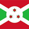
Divided by a white diagonal cross into red panels (top and bottom) and green panels (hoist side and fly side) with a white disk superimposed at the center bearing three red six-pointed stars outlined in green arranged in a triangular design (one star above, two stars below); green symbolizes hope and optimism, white purity and peace, and red the blood shed in the struggle for independence; the three stars in the disk represent the three major ethnic groups: Hutu, Twa, Tutsi, as well as the three elements in the national motto: unity, work, progress.

Burundi is a small country in East Africa bordered by Tanzania, Rwanda, and Lake Tanganyika. Burundi gained its independence from Belgium in 1962. Much of its history has been turbulent, and Burundi's first democratically elected president was assassinated in October 1993 after only 100 days in office. The internationally brokered Arusha Agreement ended the 1993-2005 civil war, paving the way for a new constitution and 2005 elections. Pierre NKURUNZIZA was elected president in 2005 and 2010 and again in a controversial election in 2015. Burundi continues to face many political and economic challenges.
Geography
| Area | ||
|---|---|---|
| Total (World Rank: 147) | 27,830 | sq km |
| Land (World Rank: 146) | 25,680 | sq km |
| Water (World Rank: 89) | 2,150 | sq km |
| Forest (World Rank: 96) | 18.80 | % |
| Comparative | slightly smaller than Maryland | |
| Landborder | ||
| 1140 | ||
| Elevation | ||
| Lowest point (World Rank: 4) | 772 | m |
| Highest point (World Rank: 91) | 2,670 | m |
| Agricultural land | ||
| Total (World Rank: 18) | 73.30 | % |
| Arable (World Rank: 16) | 38.90 | % |
| Permanent crops (World Rank: 16) | 15.60 | % |
| Permanent pastures (World Rank: 96) | 18.80 | % |
| Irrigated land (World Rank: 132) | 230 | sq km |
| Map reference | ||
| Africa | ||
| Environment | ||
| Issues |
| |
| Agreement party |
| |
| Agreement signed | Law of the Sea | |
| Hazzards |
| |
| Location | ||
| Central Africa, east of the Democratic Republic of the Congo, west of Tanzania | ||
| Climate | ||
| equatorial; high plateau with considerable altitude variation (772 m to 2,670 m above sea level); average annual temperature varies with altitude from 23 to 17 degrees Celsius but is generally moderate as the average altitude is about 1,700 m; average annual rainfall is about 150 cm; two wet seasons (February to May and September to November), and two dry seasons (June to August and December to January) | ||
| Terrain | ||
| hilly and mountainous, dropping to a plateau in east, some plains | ||
People
| Population | ||
|---|---|---|
| Total (World Rank: 78) | 11,466,800 | |
| Deathrate (World Rank: 70) | 0.88 | % |
| Birthrate (World Rank: 6) | 4.13 | % |
| Growthrate (World Rank: 5) | 3.25 | % |
| Fertility rate (World Rank: 4) | 5.99 | % |
| Median age | ||
| Male (World Rank: 218) | 16.80 | |
| Female (World Rank: 219) | 17.30 | |
| Age structure | ||
| 0 14 male (World Rank: 67) | 2,628,770 | |
| 0 14 female (World Rank: 65) | 2,596,720 | |
| 15 24 male (World Rank: 80) | 1,095,210 | |
| 15 24 female (World Rank: 78) | 1,100,310 | |
| 25 54 male (World Rank: 98) | 1,643,320 | |
| 25 54 female (World Rank: 97) | 1,651,680 | |
| 55 64 male (World Rank: 113) | 212,074 | |
| 55 64 female (World Rank: 112) | 237,324 | |
| 65 x male (World Rank: 122) | 129,482 | |
| 65 x female (World Rank: 122) | 171,865 | |
| Health | ||
| Infant mortality rate (World Rank: 19) | 5.88 | % |
| Life expectancy total (World Rank: 199) | 61 | years |
| Life expectancy female (World Rank: 198) | 63 | years |
| Life expectancy male (World Rank: 199) | 59 | years |
| Hospital bed per 1000 (World Rank: 112) | 1.90 | |
| Sanitation access total (World Rank: 161) | 48.00 | % |
| Obesity adult (World Rank: 177) | 5.40 | % |
| Drinking water access (World Rank: 170) | 75.90 | % |
Energy
| Electricity | ||
|---|---|---|
| Production (World Rank: 181) | 230,000,000 | kWh |
| Consumption (World Rank: 182) | 303,900,000 | kWh |
| Import (World Rank: 96) | 90,000,000 | kWh |
| Source fossil (World Rank: 199) | 13.20 | % |
| Source nuclear (World Rank: 13) | 83.80 | % |
| Source renew (World Rank: 99) | 4.40 | % |
| Refined products | ||
| Consumption (World Rank: 198) | 1,500 | bbl / day |
| Import (World Rank: 190) | 1,636 | bbl / day |
| Natural gas | ||
| Consumption (World Rank: 121) | 29 | m³ |
| Carbon footprint | ||
| 300000 | ||
Nation
| Budget | ||
|---|---|---|
| Education (World Rank: 48) | 5 | % of GDP |
| Military (World Rank: 46) | 2 | % of GDP |
| Health (World Rank: 66) | 8 | % of GDP |
| Surplus (World Rank: 143) | -5 | % of GDP |
| National symbol | ||
| lion | ||
| National colours | ||
| white | ||
| Adjective | ||
| Burundian | ||
| Noun | ||
| Burundian(s) | ||
| Background | ||
| Burundi is a small country in East Africa bordered by Tanzania, Rwanda, and Lake Tanganyika. Burundi gained its independence from Belgium in 1962. Much of its history has been turbulent, and Burundi's first democratically elected president was assassinated in October 1993 after only 100 days in office. The internationally brokered Arusha Agreement ended the 1993-2005 civil war, paving the way for a new constitution and 2005 elections. Pierre NKURUNZIZA was elected president in 2005 and 2010 and again in a controversial election in 2015. Burundi continues to face many political and economic challenges. | ||
| Flag description | ||
| divided by a white diagonal cross into red panels (top and bottom) and green panels (hoist side and fly side) with a white disk superimposed at the center bearing three red six-pointed stars outlined in green arranged in a triangular design (one star above, two stars below); green symbolizes hope and optimism, white purity and peace, and red the blood shed in the struggle for independence; the three stars in the disk represent the three major ethnic groups: Hutu, Twa, Tutsi, as well as the three elements in the national motto: unity, work, progress | ||
Economy
| Gdp | ||
|---|---|---|
| Purchasing power parity (World Rank: 164) | 7,849,000,000 | USD |
| Real growth rate (World Rank: 192) | -1.00 | % |
| Per capita purchasing power parity (World Rank: 224) | 800 | USD |
| Source agriculture (World Rank: 10) | 39.80 | % |
| Source industry (World Rank: 169) | 16.60 | % |
| Source service (World Rank: 193) | 43.70 | % |
| Labourforce | ||
| Total (World Rank: 83) | 4,842,000 | |
| In poverty (World Rank: 9) | 64.60 | % |
| Products | ||
| Industries |
| |
| Agriculture |
| |
| Exports |
| |
| Imports |
| |
Communication
| Phone | ||
|---|---|---|
| Landline total (World Rank: 176) | 19,540 | |
| Landline per 100 (World Rank: 213) | 1.00 | |
| Mobile per 100 (World Rank: 203) | 48.00 | |
| Assessment | 0 | |
| Internet | ||
| Users (World Rank: 145) | 574,236 | |
| Population (World Rank: 215) | 5.20 | % |
Transport
| Air | ||
|---|---|---|
| Airports paved (World Rank: 202) | 1.00 | |
| Airports unpaved (World Rank: 145) | 6.00 | |
| Heliports (World Rank: 75) | 1.00 | |
| Road | ||
| Total length (World Rank: 129) | 12,322 | |
| Paved length (World Rank: 133) | 1,500 | |
| Unpaved length (World Rank: 81) | 10,822 | |
This is a list of famous places in this country in alphabetical order.
 Bihembe
- Bihembe
- Binyuro
- Bitare
- Bogogwa
- Bubanza
- Bucarenga
- Buganda
- Bugarama
- Buhiga
- Bujumbura
- Bukanya
- Bukeye
- Buramata
- Bururi
- Butanuka
- Butihinda
- Buvyuko
- Bwiza-Bweranka
- Cankuzo
- Cibitoke
- Gacokwe
- Gahinasazi
- Gatunguru
- Gicumboro
- Gihanga
- Gishubi
- Gisuru
- Gitaba
- Gitega
- Gitohwe
- Gitongo
- Ijenda
- Isale
- Kabarore
- Kagoma
- Kanyinya
- Karonge
- Karuzi
- Kayanza
- Kibimba
- Kibonangoma
- Kigarama
- Kigwati
- Kinyinya
- Kiremba
- Kirundo
- Kivoga
- Kwibuka
- Makamba
- Manga
- Masake
- Miheto
- Minago
- Mishiha
- Mitakataka
- Mugamba
- Mugerema
- Mukoro
- Mukugu
- Munanira
- Muramvya
- Murira
- Musenyi
- Mushasha
- Musigati
- Musongati
- Muyange
- Muyebe
- Muyinga
- Mwaro
- Mwihero
- Ngozi
- Ninga
- Ntamba
- Nyabihanga
- Nyamugari
- Nyamuhunba
- Nyamutobo
- Nyanza-Lac
- Nyarunazi II
- Nyarusagare
- Nyeshanga
- Rubimba
- Rukukumbo
- Rumonge
- Rutana
- Rutegama
- Rutovu
- Ruyigi
- Rwamahasa
- Rwego
- Rwegura
- SOS Children's Village Bujumbura
- SOS Children's Village Gitega
- SOS Children's Village Rutana
- Taba
- Twinyambo
- Vumbi-Bukuba
- Zanandore