Sao Tome and Principe
in Middle Africa
Africa
- Currency and Currency Code:
- Dobra - STD
- Spoken languages:
- Portuguese
- Local electricity:
- 230 V - 50 Hz (plugs: C, F)
- Mobile phone / cellular frequencies (MHz):
- 900 MHz, 3G
- ISO 2-Letter code:
- ST
- Internet top level domain:
- .st
- Country phone prefix:
- +239
- Local Time (capital):
- Timezone:
- UTC/GMT offset: hours
Safety Score: 2,5 of 5.0 based on data from 9 authorites. Meaning we advice caution when travelling to Sao Tome and Principe.
Travel warnings are updated daily. Source: Travel Warning Sao Tome and Principe. Last Update: 2024-07-26 08:00:33
Explore Sao Tome and Principe
Sao Tome and Principe with its capital Sao Tome is located in Africa (Central Africa, islands in the Gulf of Guinea). It covers some 965 square kilometers (more than five times the size of Washington, DC) with 201,025 citizens. Portuguese is the language commonly spoken used by the people in Sao Tome and Principe. This country shares no land borders with another country.


Sao Tome and Principe is a small island nation off the Atlantic coast of Central Africa, located in the Gulf of Guinea, straddling the Equator, west of Gabon. Sao Tome & Principe were both uninhabited prior to colonization by the Portuguese. Since then, much of the landscape has remained unchanged or, where former plantations once stood, reclaimed by the rainforests. The islands are covered by lush rainforests and with a small population and very few tourists, it remains a veritible tropical paradise.he waters around Sao Tome are clear and rich with life. Consequently, diving, fishing and boat tours provide much to see. One of the few operators that offers these activities is Club Maxel.
Popular Destinations in Sao Tome and Principe
Administrative regions of Sao Tome and Principe
About the country
The landscape is volcanic, mountainous. The average density of population is about 209 per km². The climate in Sao Tome and Principe can be described as tropicalhot, humid, one rainy season (October to May). Potential threats by nature are flooding.
To reach someone Sao Tome and Principe dial +239 prior to a number. The local cellular networks are operated on 900 MHz, 3G. Websites typically end with the top level domain ".st". If you want to bring electric appliances (e.g. battery chaarger), keep in min the local 230 V - 50 Hz (plugs: C, F). The sign for the locally used currency Dobra is STD.
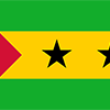
Three horizontal bands of green (top), yellow (double width), and green with two black five-pointed stars placed side by side in the center of the yellow band and a red isosceles triangle based on the hoist side; green stands for the country's rich vegetation, red recalls the struggle for independence, and yellow represents cocoa, one of the country's main agricultural products; the two stars symbolize the two main islands.

Discovered and claimed by Portugal in the late 15th century, the islands' sugar-based economy gave way to coffee and cocoa in the 19th century - all grown with African plantation slave labor, a form of which lingered into the 20th century. While independence was achieved in 1975, democratic reforms were not instituted until the late 1980s. The country held its first free elections in 1991, but frequent internal wrangling between the various political parties precipitated repeated changes in leadership and four failed, non-violent coup attempts in 1995, 1998, 2003, and 2009. In 2012, three opposition parties combined in a no confidence vote to bring down the majority government of former Prime Minister Patrice TROVOADA, but in 2014, legislative elections returned him to the office. President Evaristo CARVALHO, of the same political party as Prime Minister TROVOADA, was elected in September 2016, marking a rare instance in which the positions of president and prime minister are held by the same party. New oil discoveries in the Gulf of Guinea may attract increased attention to the small island nation.
Geography
| Area | ||
|---|---|---|
| Total (World Rank: 185) | 964 | sq km |
| Land (World Rank: 182) | 964 | sq km |
| Forest (World Rank: 187) | 1.00 | % |
| Comparative | more than five times the size of Washington, DC | |
| Coastline | ||
| 209 | ||
| Elevation | ||
| Highest point (World Rank: 123) | 2,024 | m |
| Agricultural land | ||
| Total (World Rank: 68) | 50.70 | % |
| Arable (World Rank: 120) | 9.10 | % |
| Permanent crops (World Rank: 3) | 40.60 | % |
| Permanent pastures (World Rank: 187) | 1.00 | % |
| Irrigated land (World Rank: 142) | 100 | sq km |
| Map reference | ||
| Africa | ||
| Environment | ||
| Issues |
| |
| Agreement party |
| |
| Hazzards | flooding | |
| Location | ||
| Central Africa, islands in the Gulf of Guinea, just north of the Equator, west of Gabon | ||
| Climate | ||
| tropical; hot, humid; one rainy season (October to May) | ||
| Terrain | ||
| volcanic, mountainous | ||
People
| Population | ||
|---|---|---|
| Total (World Rank: 183) | 201,025 | |
| Deathrate (World Rank: 136) | 0.68 | % |
| Birthrate (World Rank: 31) | 3.24 | % |
| Growthrate (World Rank: 60) | 1.72 | % |
| Migration rate (World Rank: 172) | -0.83 | % |
| Fertility rate (World Rank: 30) | 4.25 | % |
| Median age | ||
| Male (World Rank: 210) | 18.00 | |
| Female (World Rank: 208) | 18.80 | |
| Age structure | ||
| 0 14 male (World Rank: 177) | 42,781 | |
| 0 14 female (World Rank: 175) | 41,354 | |
| 15 24 male (World Rank: 182) | 21,070 | |
| 15 24 female (World Rank: 182) | 20,507 | |
| 25 54 male (World Rank: 186) | 30,454 | |
| 25 54 female (World Rank: 185) | 31,509 | |
| 55 64 male (World Rank: 202) | 3,515 | |
| 55 64 female (World Rank: 198) | 4,140 | |
| 65 x male (World Rank: 205) | 2,523 | |
| 65 x female (World Rank: 204) | 3,172 | |
| Health | ||
| Infant mortality rate (World Rank: 40) | 4.53 | % |
| Life expectancy total (World Rank: 175) | 65 | years |
| Life expectancy female (World Rank: 180) | 67 | years |
| Life expectancy male (World Rank: 172) | 64 | years |
| Hospital bed per 1000 (World Rank: 74) | 2.90 | |
| Sanitation access total (World Rank: 176) | 34.70 | % |
| Obesity adult (World Rank: 133) | 12.40 | % |
| Drinking water access (World Rank: 92) | 97.10 | % |
Energy
| Electricity | ||
|---|---|---|
| Production (World Rank: 202) | 66,000,000 | kWh |
| Consumption (World Rank: 201) | 61,380,000 | kWh |
| Source fossil (World Rank: 91) | 80.00 | % |
| Source nuclear (World Rank: 85) | 20.00 | % |
| Refined products | ||
| Consumption (World Rank: 204) | 1,000 | bbl / day |
| Import (World Rank: 199) | 1,001 | bbl / day |
| Natural gas | ||
| Consumption (World Rank: 157) | 9 | m³ |
| Carbon footprint | ||
| 100000 | ||
Nation
| Budget | ||
|---|---|---|
| Education (World Rank: 112) | 4 | % of GDP |
| Health (World Rank: 48) | 8 | % of GDP |
| Surplus (World Rank: 135) | -4 | % of GDP |
| National symbol | ||
| palm tree | ||
| National colours | ||
| yellow | ||
| Adjective | ||
| Sao Tomean | ||
| Noun | ||
| Sao Tomean(s) | ||
| Background | ||
| Discovered and claimed by Portugal in the late 15th century, the islands' sugar-based economy gave way to coffee and cocoa in the 19th century - all grown with African plantation slave labor, a form of which lingered into the 20th century. While independence was achieved in 1975, democratic reforms were not instituted until the late 1980s. The country held its first free elections in 1991, but frequent internal wrangling between the various political parties precipitated repeated changes in leadership and four failed, non-violent coup attempts in 1995, 1998, 2003, and 2009. In 2012, three opposition parties combined in a no confidence vote to bring down the majority government of former Prime Minister Patrice TROVOADA, but in 2014, legislative elections returned him to the office. President Evaristo CARVALHO, of the same political party as Prime Minister TROVOADA, was elected in September 2016, marking a rare instance in which the positions of president and prime minister are held by the same party. New oil discoveries in the Gulf of Guinea may attract increased attention to the small island nation. | ||
| Flag description | ||
| three horizontal bands of green (top), yellow (double width), and green with two black five-pointed stars placed side by side in the center of the yellow band and a red isosceles triangle based on the hoist side; green stands for the country's rich vegetation, red recalls the struggle for independence, and yellow represents cocoa, one of the country's main agricultural products; the two stars symbolize the two main islands | ||
Economy
| Gdp | ||
|---|---|---|
| Purchasing power parity (World Rank: 208) | 638,000,000 | USD |
| Real growth rate (World Rank: 61) | 4.10 | % |
| Per capita purchasing power parity (World Rank: 189) | 3,100 | USD |
| Source agriculture (World Rank: 79) | 12.10 | % |
| Source industry (World Rank: 179) | 14.80 | % |
| Source service (World Rank: 54) | 73.20 | % |
| Labourforce | ||
| Total (World Rank: 184) | 67,870 | |
| In poverty (World Rank: 8) | 66.20 | % |
| Products | ||
| Industries |
| |
| Agriculture |
| |
| Exports |
| |
| Imports |
| |
Communication
| Phone | ||
|---|---|---|
| Landline total (World Rank: 200) | 5,733 | |
| Landline per 100 (World Rank: 170) | 3.00 | |
| Mobile per 100 (World Rank: 186) | 68.00 | |
| Assessment | 0 | |
| Internet | ||
| Users (World Rank: 191) | 50,000 | |
| Population (World Rank: 166) | 25.80 | % |
Transport
| Air | ||
|---|---|---|
| Airports paved (World Rank: 178) | 2.00 | |
| Road | ||
| Total length (World Rank: 204) | 320 | |
| Paved length (World Rank: 167) | 218.00 | |
| Unpaved length (World Rank: 146) | 102.00 | |
This is a list of famous places in this country in alphabetical order.
 A. Andrade
- Abade
- Agua Bobo
- Agua Ize
- Agua-Coco
- Almeirim
- Alto Douro
- Anselmo de Andrade
- Bela Vista
- Belo Monte
- Blublu
- Boa Morte
- Bombom
- Bombon
- Buenos Aires
- Caixao Grande
- Campainha
- Cantagalo
- Cascalheira
- Conde
- Cruzeiro
- Dona Augusta
- Dona Eugenia
- Enjale
- Esperanca
- Folha Fede
- Fundacao Popular
- Futuro
- Generosa
- Graca
- Guegue Novo
- Henrique
- Lemba
- Lemos
- M. Alice
- Macambrara
- Madalena
- Mantero
- Micolo
- Montalvao
- Monte Rosa
- N'zumbi
- N. Ceilao
- Nazare
- Neves
- Neves Ferreira
- Nova Cuba
- Nova Moca
- Novo Brasil
- Oque Gaspar
- Oque Rosario
- Paciencia
- Paufita
- Piedade
- Ponta Figo
- Ponta Forte
- Ponta Furada
- Porto Alegre
- Porto Algere
- Porto Real
- Praia Inhame
- Quimpo
- Ribeira Afonso
- Ribeira Ize
- Riboque Santana
- Rosema
- Santa Catarina
- Santa Clotilde
- Santa Cruz
- Santa Elvira
- Santa Isabel
- Santa Joaquina
- Santa Josefina
- Santa Rita
- Santa Trindade
- Santana
- Santana
- Santo Amaro
- Santo Antonio
- Santo Antonio
- Santo Cristo
- Sao Carlos do Fundao
- Sao Jeronimo
- Sao Jeronimo
- Sao Joao
- Sao Joao
- Sao Joao dos Angolares
- Sao Joaquim
- Sao Jorge
- Sao Jose Picate
- Sao Luis
- Sao Manuel
- Sao Mateus
- Sao Tome
- Sundi
- Tras os Montes
- Trindade
- Uba Flor
- Vila Maria
- Vila Rosa