American Samoa
in Polynesia
Oceania
- Currency and Currency Code:
- Dollar - USD
- Spoken languages:
- English, Samoan, Tonga
- Local electricity:
- 120 V - 60 Hz (plugs: A, B, F, I)
- Mobile phone / cellular frequencies (MHz):
- 850 MHz, 1900 MHz, 3G, 4G
- ISO 2-Letter code:
- AS
- Internet top level domain:
- .as
- Country phone prefix:
- +1-684
- Local Time (capital):
- Timezone:
- UTC/GMT offset: hours
Explore American Samoa
American Samoa with its capital Pago Pago is located in Oceania (Oceania, group of islands in the South Pacific Ocean). It covers some 200 square kilometers (slightly larger than Washington, DC) with 51,504 citizens. English, Samoan and Tonga are the languages commonly used by the people in American Samoa (consider regional differences). This country shares no land borders with another country.
American Samoa is a group of islands in the South Pacific Ocean that lie about halfway between Hawaii and New Zealand and about 100km east of the island country of Samoa, which is part of the same archipelago. The islands are frequently referred to as Samoa, which is the name of a separate island, and independent country, that used to be known as Western Samoa, that lies about 100km west of American Samoa. Also the whole island group, including Samoa, are often identified as the Samoan islands.
Popular Destinations in American Samoa
Administrative regions of American Samoa
About the country
P.O. Box 1147
Pago Pago
American Samoa 96799
USA
Phone: +684 633 1092
Fax: +684 633 2092
Mail: amsamoa@amerikasamoa.info
The landscape is five volcanic islands with rugged peaks and limited coastal plains, two coral atolls (Rose Island, Swains Island). The average density of population is about 259 per km². The climate in American Samoa can be described as tropical marine, moderated by southeast trade windsannual rainfall averages about 3 m, rainy season (November to April), dry season (May to October), little seasonal temperature variation. Potential threats by nature are cyclones common from December to March limited volcanic activity on the Ofu and Olosega Islands; neither has erupted since the 19th century
To reach someone American Samoa dial +1-684 prior to a number. The local cellular networks are operated on 850 MHz, 1900 MHz, 3G, 4G. Websites typically end with the top level domain ".as". If you want to bring electric appliances (e.g. battery chaarger), keep in min the local 120 V - 60 Hz (plugs: A, B, F, I). The sign for the locally used currency Dollar is USD.
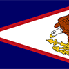
Blue, with a white triangle edged in red that is based on the fly side and extends to the hoist side; a brown and white American bald eagle flying toward the hoist side is carrying two traditional Samoan symbols of authority, a war club known as a "fa'alaufa'i" (upper; left talon), and a coconut fiber fly whisk known as a "fue" (lower; right talon); the combination of symbols broadly mimics that seen on the US Great Seal and reflects the relationship between the US and American Samoa.

Settled as early as 1000 B.C., Samoa was not reached by European explorers until the 18th century. International rivalries in the latter half of the 19th century were settled by an 1899 treaty in which Germany and the US divided the Samoan archipelago. The US formally occupied its portion - a smaller group of eastern islands with the excellent harbor of Pago Pago - the following year.
Geography
| Area | ||
|---|---|---|
| Total (World Rank: 213) | 199 | sq km |
| Land (World Rank: 210) | 199 | sq km |
| Comparative | slightly larger than Washington, DC | |
| Note | includes Rose Island and Swains Island | |
| Coastline | ||
| 116 | ||
| Elevation | ||
| Highest point (World Rank: 166) | 964 | m |
| Agricultural land | ||
| Total (World Rank: 160) | 21.70 | % |
| Arable (World Rank: 87) | 13.30 | % |
| Permanent crops (World Rank: 41) | 8.40 | % |
| Map reference | ||
| Oceania | ||
| Environment | ||
| Issues |
| |
| Hazzards |
| |
| Location | ||
| Oceania, group of islands in the South Pacific Ocean, about halfway between Hawaii and New Zealand | ||
| Climate | ||
| tropical marine, moderated by southeast trade winds; annual rainfall averages about 3 m; rainy season (November to April), dry season (May to October); little seasonal temperature variation | ||
| Terrain | ||
| five volcanic islands with rugged peaks and limited coastal plains, two coral atolls (Rose Island, Swains Island) | ||
People
| Population | ||
|---|---|---|
| Total (World Rank: 208) | 51,504 | |
| Deathrate (World Rank: 170) | 0.59 | % |
| Birthrate (World Rank: 81) | 1.96 | % |
| Growthrate (World Rank: 226) | -1.30 | % |
| Migration rate (World Rank: 186) | -2.67 | % |
| Fertility rate (World Rank: 68) | 2.68 | % |
| Median age | ||
| Male (World Rank: 111) | 29.90 | |
| Female (World Rank: 128) | 28.80 | |
| Age structure | ||
| 0 14 male (World Rank: 199) | 8,017 | |
| 0 14 female (World Rank: 199) | 7,580 | |
| 15 24 male (World Rank: 200) | 4,846 | |
| 15 24 female (World Rank: 199) | 4,831 | |
| 25 54 male (World Rank: 209) | 9,274 | |
| 25 54 female (World Rank: 208) | 9,463 | |
| 55 64 male (World Rank: 210) | 2,186 | |
| 55 64 female (World Rank: 209) | 2,232 | |
| 65 x male (World Rank: 213) | 1,452 | |
| 65 x female (World Rank: 210) | 1,623 | |
| Health | ||
| Infant mortality rate (World Rank: 146) | 0.85 | % |
| Life expectancy total (World Rank: 107) | 75 | years |
| Life expectancy female (World Rank: 100) | 79 | years |
| Life expectancy male (World Rank: 110) | 72 | years |
| Sanitation access total (World Rank: 148) | 62.50 | % |
| Drinking water access (World Rank: 33) | 100.00 | % |
Energy
| Electricity | ||
|---|---|---|
| Production (World Rank: 184) | 200,000,000 | kWh |
| Consumption (World Rank: 197) | 100,000,000 | kWh |
| Source fossil (World Rank: 23) | 100.00 | % |
| Refined products | ||
| Consumption (World Rank: 189) | 2,375 | bbl / day |
| Import (World Rank: 183) | 2,346 | bbl / day |
| Carbon footprint | ||
| 600000 | ||
Economy
| Gdp | ||
|---|---|---|
| Purchasing power parity (World Rank: 206) | 711,000,000 | USD |
| Real growth rate (World Rank: 199) | -2.40 | % |
| Per capita purchasing power parity (World Rank: 116) | 13,000 | USD |
| Source agriculture (World Rank: 22) | 27.40 | % |
| Source industry (World Rank: 193) | 12.40 | % |
| Source service (World Rank: 123) | 60.20 | % |
| Labourforce | ||
| Total (World Rank: 211) | 16,090 | |
| Products | ||
| Industries |
| |
| Agriculture |
| |
| Exports | canned tuna | |
| Imports |
| |
Nation
| Budget | ||
|---|---|---|
| Surplus (World Rank: 46) | -0 | % of GDP |
| National symbol | ||
| a fue crossed with a to'oto'o | ||
| National colours | ||
| white | ||
| Adjective | ||
| American Samoan | ||
| Noun | ||
| American Samoan(s) (US nationals) | ||
| Background | ||
| Settled as early as 1000 B.C., Samoa was not reached by European explorers until the 18th century. International rivalries in the latter half of the 19th century were settled by an 1899 treaty in which Germany and the US divided the Samoan archipelago. The US formally occupied its portion - a smaller group of eastern islands with the excellent harbor of Pago Pago - the following year. | ||
| Flag description | ||
| blue, with a white triangle edged in red that is based on the fly side and extends to the hoist side; a brown and white American bald eagle flying toward the hoist side is carrying two traditional Samoan symbols of authority, a war club known as a "fa'alaufa'i" (upper; left talon), and a coconut fiber fly whisk known as a "fue" (lower; right talon); the combination of symbols broadly mimics that seen on the US Great Seal and reflects the relationship between the US and American Samoa | ||
Communication
| Phone | ||
|---|---|---|
| Landline total (World Rank: 193) | 10,000 | |
| Landline per 100 (World Rank: 97) | 18.00 | |
| Assessment | 0 | |
| Internet | ||
| Users (World Rank: 204) | 17,000 | |
| Population (World Rank: 153) | 31.30 | % |
Transport
| Air | ||
|---|---|---|
| Airports paved (World Rank: 170) | 3.00 | |
| Road | ||
| Total length (World Rank: 207) | 241.00 | |
This is a list of famous places in this country in alphabetical order.
 'Amanave
- 'Aoa
- A'oloaufou
- Aasu
- Afao
- Afono
- Aganoa
- Agugulu
- Alao
- Alaufau
- Alega
- Alofau
- Amaluia
- Amaua
- Amouli
- Anasosopo
- Anua
- Aoloau
- Asili
- Atu'u
- Aua
- Auasi
- Auma
- Aumi
- Aunu'u
- Autapini
- Auto
- Avaio
- Faalefu
- Faga'alu
- Faga'itua
- Fagalea
- Fagalele
- Fagali'i
- Fagamalo
- Faganeanea
- Fagasa
- Fagatogo
- Failolo
- Faleasao
- Faleniu
- Falili
- Fatumafuti
- Fitiuta
- Fogaau
- Fogagogo
- Fusi
- Futiga
- Ili'ili
- Lalopua
- Lauli'i
- Lauliifou
- Lauliituai
- Leloaloa
- Leone
- Lepine
- Malaeimi
- Malaeloa/Aitulagi
- Malaeloa/Ituau
- Malaloa
- Maloata
- Mapusaga
- Mapusagafou
- Masausi
- Matu'u
- Mesepa
- Nu'uuli
- Ofu
- Olosega
- Oneoneloa
- Ottoville
- Pagai
- Pago Pago
- Pava'ia'i
- Poloa
- Sa'ilele
- Satala
- Se'etaga
- Si'ufaga
- Si'ufaga
- Sogi
- Ta`u
- Tafananai
- Tafeta
- Tafuna
- Tafunafou
- Tagapofu
- Taputimu
- Taulaga
- Tuaolo
- Tula
- Utulei
- Utumea
- Utumea East
- Utusia
- Vaiala
- Vailoatai
- Vaitogi
- Vasaaiga
- Vatia