Turks and Caicos Islands
in Caribbean
North America
- Currency and Currency Code:
- Dollar - USD
- Spoken languages:
- English
- Local electricity:
- 120 V - 60 Hz (plugs: A, B)
- Mobile phone / cellular frequencies (MHz):
- 850 MHz, 900 MHz, 1800 MHz, 1900 MHz, 3G, 4G
- ISO 2-Letter code:
- TC
- Internet top level domain:
- .tc
- Country phone prefix:
- +1-649
- Local Time (capital):
- Timezone:
- UTC/GMT offset: hours
Safety Score: 3,0 of 5.0 based on data from 9 authorites. Meaning we advice caution when travelling to Turks and Caicos Islands.
Travel warnings are updated daily. Source: Travel Warning Turks and Caicos Islands. Last Update: 2024-04-19 08:03:45
Explore Turks and Caicos Islands
Turks and Caicos Islands with its capital Cockburn Town is located in North America (two island groups in the North Atlantic Ocean, southeast of The Bahamas). It covers some 949 square kilometers (2.5 times the size of Washington, DC) with a population of 52,570. English is the official language spoken by people in Turks and Caicos Islands. Thiscountry has no land-based border with any other country.
The Turks and Caicos Islands are only 37 miles long, and all together consist of 40 islands and cays. There are two main islands, Grand Turk (Turk Island) and Providenciales (Caicos Island). These islands are on 550 miles South from Florida. The islands have fabulous beaches throughout, in particular, the award winning Grace Bay. There also is a variety of fun, non-beach things that there are to do. You can scuba dive, snorkle, sail, boat, parasail, fish, go on tours, go to spas and salons, golf, shop, and gamble. Each island has their own activities as well. Below are a few activities that are available on the islands.
Popular Destinations in Turks and Caicos Islands
Administrative regions of Turks and Caicos Islands
About the country
The topography is low, flat limestone with extensive marshes and mangrove swamps. The average density of population is about 55 per km². The climate in Turks and Caicos Islands can be described as tropicalmarine, moderated by trade winds, sunny and relatively dry. Potential natural disasters are frequent hurricanes.
To reach someone Turks and Caicos Islands dial +1-649 prior to a number. The local cellular networks are operated on 850 MHz, 900 MHz, 1800 MHz, 1900 MHz, 3G, 4G. Websites typically end with the top level domain ".tc". If you want to bring electric appliances (e.g. battery chaarger), keep in min the local 120 V - 60 Hz (plugs: A, B). The sign for the locally used currency Dollar is USD.
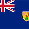
Blue with the flag of the UK in the upper hoist-side quadrant and the colonial shield centered on the outer half of the flag; the shield is yellow and displays a conch shell, a spiny lobster, and Turk's cap cactus - three common elements of the islands' biota.

The islands were part of the UK's Jamaican colony until 1962, when they assumed the status of a separate crown colony upon Jamaica's independence. The governor of The Bahamas oversaw affairs from 1965 to 1973. With Bahamian independence, the islands received a separate governor in 1973. Although independence was agreed upon for 1982, the policy was reversed and the islands remain a British overseas territory. Grand Turk island suffered extensive damage from Hurricane Maria on 22 September 2017 resulting in loss of power and communications as well as damage to housing and businesses.
Geography
| Area | ||
|---|---|---|
| Total (World Rank: 186) | 948 | sq km |
| Land (World Rank: 183) | 948 | sq km |
| Comparative | 2.5 times the size of Washington, DC | |
| Coastline | ||
| 389 | ||
| Elevation | ||
| Highest point (World Rank: 229) | 48 | m |
| Agricultural land | ||
| Total (World Rank: 219) | 1.10 | % |
| Arable (World Rank: 196) | 1.10 | % |
| Map reference | ||
| Central America and the Caribbean | ||
| Environment | ||
| Issues |
| |
| Hazzards | frequent hurricanes | |
| Location | ||
| two island groups in the North Atlantic Ocean, southeast of The Bahamas, north of Haiti | ||
| Climate | ||
| tropical; marine; moderated by trade winds; sunny and relatively dry | ||
| Terrain | ||
| low, flat limestone; extensive marshes and mangrove swamps | ||
People
| Population | ||
|---|---|---|
| Total (World Rank: 206) | 52,570 | |
| Deathrate (World Rank: 219) | 0.32 | % |
| Birthrate (World Rank: 124) | 1.53 | % |
| Growthrate (World Rank: 36) | 2.20 | % |
| Migration rate (World Rank: 10) | 0.95 | % |
| Fertility rate (World Rank: 170) | 1.70 | % |
| Median age | ||
| Male (World Rank: 84) | 33.20 | |
| Female (World Rank: 100) | 32.50 | |
| Age structure | ||
| 0 14 male (World Rank: 205) | 5,826 | |
| 0 14 female (World Rank: 205) | 5,604 | |
| 15 24 male (World Rank: 208) | 3,641 | |
| 15 24 female (World Rank: 206) | 3,711 | |
| 25 54 male (World Rank: 201) | 14,097 | |
| 25 54 female (World Rank: 200) | 13,855 | |
| 55 64 male (World Rank: 213) | 1,839 | |
| 55 64 female (World Rank: 214) | 1,597 | |
| 65 x male (World Rank: 215) | 1,096 | |
| 65 x female (World Rank: 215) | 1,304 | |
| Health | ||
| Infant mortality rate (World Rank: 131) | 1.04 | % |
| Life expectancy total (World Rank: 43) | 80 | years |
| Life expectancy female (World Rank: 45) | 83 | years |
| Life expectancy male (World Rank: 43) | 77 | years |
| Sanitation access total (World Rank: 120) | 81.40 | % |
Energy
| Electricity | ||
|---|---|---|
| Production (World Rank: 188) | 200,000,000 | kWh |
| Consumption (World Rank: 188) | 200,000,000 | kWh |
| Source fossil (World Rank: 16) | 100.00 | % |
| Refined products | ||
| Consumption (World Rank: 199) | 1,340 | bbl / day |
| Import (World Rank: 196) | 1,328 | bbl / day |
| Carbon footprint | ||
| 200000 | ||
Nation
| Budget | ||
|---|---|---|
| Education (World Rank: 128) | 3 | % of GDP |
| National symbol | ||
| Turk's cap cactus | ||
| Adjective | ||
| none | ||
| Noun | ||
| none | ||
| Background | ||
| The islands were part of the UK's Jamaican colony until 1962, when they assumed the status of a separate crown colony upon Jamaica's independence. The governor of The Bahamas oversaw affairs from 1965 to 1973. With Bahamian independence, the islands received a separate governor in 1973. Although independence was agreed upon for 1982, the policy was reversed and the islands remain a British overseas territory. Grand Turk island suffered extensive damage from Hurricane Maria on 22 September 2017 resulting in loss of power and communications as well as damage to housing and businesses. | ||
| Flag description | ||
| blue with the flag of the UK in the upper hoist-side quadrant and the colonial shield centered on the outer half of the flag; the shield is yellow and displays a conch shell, a spiny lobster, and Turk's cap cactus - three common elements of the islands' biota | ||
Economy
| Gdp | ||
|---|---|---|
| Purchasing power parity (World Rank: 209) | 632,000,000 | USD |
| Real growth rate (World Rank: 2) | 11.20 | % |
| Per capita purchasing power parity (World Rank: 63) | 29,100 | USD |
| Source agriculture (World Rank: 208) | 0.50 | % |
| Source industry (World Rank: 208) | 9.00 | % |
| Source service (World Rank: 7) | 90.50 | % |
| Labourforce | ||
| Total (World Rank: 217) | 4,848 | |
| Products | ||
| Industries |
| |
| Agriculture |
| |
| Exports |
| |
| Imports |
| |
Transport
| Air | ||
|---|---|---|
| Airports paved (World Rank: 139) | 6.00 | |
| Airports unpaved (World Rank: 176) | 2.00 | |
| Road | ||
| Total length (World Rank: 213) | 121.00 | |
| Paved length (World Rank: 185) | 24.00 | |
| Unpaved length (World Rank: 147) | 97.00 | |
Communication
| Phone | ||
|---|---|---|
| Assessment | 0 | |
This is a list of famous places in this country in alphabetical order.
 Balfour Town
- Bambarra
- Belleview
- Belmont
- Belvedere
- Cockburn Harbour
- Cockburn Town
- Conch Bar
- Corrinice
- Fish-hawks Mark
- Five Cays Settlement
- Greenwich
- High Rock
- Highland House
- Karmont
- Kew
- Kingston
- Laughland
- Lorimers
- Lower Bight
- Major Hill
- North District
- North Windsor
- Palm Grove
- Richmond
- Sandy Point
- South District
- South Windsor
- The Flat
- The Pillory
- Wheeland
- Whitby