Safety Score: 3,0 of 5.0 based on data from 9 authorites. Meaning we advice caution when travelling to Germany.
Travel warnings are updated daily. Source: Travel Warning Germany. Last Update: 2024-04-20 08:25:34
Delve into Meindorf
Meindorf in Cologne District (North Rhine-Westphalia) is a city located in Germany about 295 mi (or 474 km) south-west of Berlin, the country's capital town.
Current time in Meindorf is now 02:27 PM (Saturday). The local timezone is named Europe / Berlin with an UTC offset of 2 hours. We know of 9 airports closer to Meindorf, of which 4 are larger airports. The closest airport in Germany is Cologne Bonn Airport in a distance of 6 mi (or 10 km), North. Besides the airports, there are other travel options available (check left side).
There are several Unesco world heritage sites nearby. The closest heritage site in Germany is Castles of Augustusburg and Falkenlust at Brühl in a distance of 10 mi (or 17 km), West. We saw 2 points of interest near this location. In need of a room? We compiled a list of available hotels close to the map centre further down the page.
Since you are here already, you might want to pay a visit to some of the following locations: Bonn, Siegburg, Alfter, Hennef and Wachtberg. To further explore this place, just scroll down and browse the available info.
Local weather forecast
Todays Local Weather Conditions & Forecast: 4°C / 40 °F
| Morning Temperature | 3°C / 38 °F |
| Evening Temperature | 7°C / 45 °F |
| Night Temperature | 5°C / 41 °F |
| Chance of rainfall | 4% |
| Air Humidity | 97% |
| Air Pressure | 1021 hPa |
| Wind Speed | Moderate breeze with 9 km/h (6 mph) from South-East |
| Cloud Conditions | Overcast clouds, covering 99% of sky |
| General Conditions | Light rain |
Sunday, 21st of April 2024
9°C (49 °F)
5°C (40 °F)
Moderate rain, gentle breeze, overcast clouds.
Monday, 22nd of April 2024
9°C (48 °F)
5°C (40 °F)
Overcast clouds, light breeze.
Tuesday, 23rd of April 2024
8°C (46 °F)
5°C (41 °F)
Light rain, light breeze, overcast clouds.
Hotels and Places to Stay
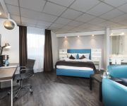
Best Western Cologne Airport
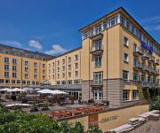
Hilton Bonn
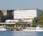
Ameron Königshof
Wald-Café Hotel-Restaurant
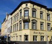
Baden
Deutsches Haus
Bonn Voyage
Bonn City
Savoy Bonn
K314 Boardinghouse
Videos from this area
These are videos related to the place based on their proximity to this place.
[PRESSLUFT + LED] 2x RTW Feuerwehr Troisdorf + RTW 4/83-1 RW Eitorf (HD)
Einsatz für die hauptamlichen Einsatzkräfte der Feuerwehr Troisdorf, 2 Rettungswagen (RTWs) fahren mit Pressluft schön aus der Feuerwache raus und Abends kommt der RTW 4/83-1 (Rettungswache ...
Clever fit Sankt Augustin The Movie
Besucht uns auch auf Facebook unter: https://www.facebook.com/cleverfit.sankt.augustin Fitness Studio für Zirkeltraining, Kraft- und Ausdauer sowie Freihantel Training, Vibrationstraining,...
Bikercamp 2008 Bundespolizei St. Augustin-Hangelar
Anfahrt und Einfahrt zum Bikercamp 2008 in St.Augustin-Hangelar (Flugplatz) im Rahmen des BIB2008 (Biker in der Bundespolizei).
GSG 9-BPOL-Fallschirmspringer-Übung (Lange Version)
Einsatzfahrten und so auf Facebook: http://www.facebook.com/EinsatzfahrtenUndSo Am 16.05.2013 übten Beamte der GSG 9 der Bundespolizei das Abspringen, das Gleiten und das Landen mit einem ...
33. Volkslauf Rund um den Flugplatz des TV Hangelar 1962 e.V.
Der 33. Volkslauf "Rund um den Flugplatz" Bonn/Hangelar zog am 11. Oktober 2014 über 400 Läuferinnen und Läufer der Region Bonn/Rhein-Sieg in seinen Bann.
Gyrocopter (Sichtflug)
Filmed with Sony Nex VG20, Edited with Sony Vegas, Adobe AE CS5.5 and Mercalli ProDAD --- GER --- Ein Partnerflug zu Königswinter mit Tragschrauber (Gyrocopter) von der Firma Sichtflug. Flugzeit ...
standlauf ec120 colibri
hier sieht man den standlauf (es war ein test ob alle wartungsarbeiten richtig gemacht worden sind) einer ec120 colibri bei der bundespolizeifliegerstaffel west in st. augustin bei bonn. bei...
Cockpit Video: Robinson R22 D-HIKS
Robinson R22 D-HIKS of Air Lloyd departing at Bonn-Hangelar, Germany.
Videos provided by Youtube are under the copyright of their owners.
Attractions and noteworthy things
Distances are based on the centre of the city/town and sightseeing location. This list contains brief abstracts about monuments, holiday activities, national parcs, museums, organisations and more from the area as well as interesting facts about the region itself. Where available, you'll find the corresponding homepage. Otherwise the related wikipedia article.
Agger (river)
The Agger is a river in Germany, a right tributary of the Sieg in North Rhine-Westphalia. It is 64 km long. Its source is in the Sauerland hills, near Meinerzhagen. It winds through the towns Engelskirchen, Overath and Lohmar. Near Siegburg the Agger flows into the Sieg.
Holzlar
Holzlar Is an enclosed settlement in Bonn's district Beuel, east of the Rhine and north of the Siebengebirge in Germany. Holzlar has a population of about 11.000 and consists out of the former villages Holzlar, Kohlkaul, Heidebergen, Roleber and Gielgen. Today the borders of the villages are no longer visible.
Wissenschaftlicher Katholischer Studentenverein Unitas Stolzenfels zu Bonn
The Wissenschaftliche Katholische Studentenverein (W.K. St.V. ) Unitas Stolzenfels Bonn was established in 1910. It is a catholic student fraternity at the University of Bonn in Germany. It is member of the Unitas Verband (UV) an umbrella organisation of several catholic fraternities and sororities. Unitas Stolzenfels is the second oldest of the four today existing Unitas associations in Bonn. Others are W.K. St.V. Unitas-Salia (1847), W.K. St.V. Unitas Rhenania (1912) and the sorority W.K.
Beethoven House
The Beethoven House in Bonn, Germany, is a memorial site, museum and cultural institution serving various purposes. Founded in 1889 by the Beethoven-Haus association, it studies the life and work of composer Ludwig van Beethoven. The centrepiece of the Beethoven-Haus is Beethoven's birthplace at Bonngasse 20. This building houses the museum.
Heimatmuseum Beuel
The Heimatmuseum Beuel is a local history museum in Bonn, Germany. The museum was established in 1986 on the initiative of Beuel's Local Historical Society. The museum is divided into four buildings, which form a closed courtyard, in former Steinerstraße, now Wagnergasse. The oldest of the four buildings dates back to 1662.
Bonn-Beuel station
Bonn-Beuel station is on the East Rhine Railway in the Bonn district of Beuel in the German state of North Rhine-Westphalia. It was opened on 1 March 1871 and has three platform tracks and several sidings. Next to it is the Rhein-Sieg-Eisenbahn station, the terminus of the Beuel–Großenbusch Light Railway, which is used by special passenger services, especially during Pützchen’s market (a five or six day fair usually held in September).
Troisdorf station
Troisdorf station is a railway junction in the town of Troisdorf in the German state of North Rhine-Westphalia, where the line from Cologne separates into the East Rhine Railway to Neuwied and the Sieg Railway to Siegen. In addition to various regional rail services Troisdorf is served by the S 12 and S 13. Both lines operate towards Cologne at 20 minute intervals, so together they provide a 10 minute interval S-Bahn service to Cologne.
Junges Theater Bonn
Junges Theater Bonn is a theatre in North Rhine-Westphalia, Germany.







!['[PRESSLUFT + LED] 2x RTW Feuerwehr Troisdorf + RTW 4/83-1 RW Eitorf (HD)' preview picture of video '[PRESSLUFT + LED] 2x RTW Feuerwehr Troisdorf + RTW 4/83-1 RW Eitorf (HD)'](https://img.youtube.com/vi/PhupQ3TBVJQ/mqdefault.jpg)


