Bahamas
in Caribbean
North America
- Currency and Currency Code:
- Dollar - BSD
- Spoken languages:
- English
- Local electricity:
- 120 V - 60 Hz (plugs: A, B)
- Mobile phone / cellular frequencies (MHz):
- 1900 MHz, 3G, 4G
- ISO 2-Letter code:
- BS
- Internet top level domain:
- .bs
- Country phone prefix:
- +1-242
- Local Time (capital):
- Timezone:
- UTC/GMT offset: hours
Safety Score: 3,0 of 5.0 based on data from 9 authorites. Meaning we advice caution when travelling to Bahamas.
Travel warnings are updated daily. Source: Travel Warning Bahamas. Last Update: 2024-04-18 08:12:24
Explore Bahamas
Bahamas with its capital Nassau is located in North America (chain of islands in the North Atlantic Ocean, southeast of Florida). It covers some 13,881 square kilometers (slightly smaller than Connecticut) with 329,988 citizens. English is the language commonly spoken used in Bahamas. This country shares no land borders with another country.
The Bahamas (or The Bahama Islands) is an archipelago consisting of many islands. There are about 2,000 islands if you include the cays which are small islands that are formed on coral reefs. The word Bahamas is of Spanish decent and means Shallow Water. Several cruise lines operate private island retreats in the Bahamas. Disney Cruise Line owns Castaway Cay, Norweigan Cruise Line owns Great Stirrup Cay, Princess Cruise Line owns Little Stirrup Cay, and Royal Caribbean owns Coco Cay. To visit these islands you usually have to be a passenger on the cruise line that owns the island. Seeing as though the water is a big part of the Bahamas, it’s the perfect condition for water sports, kiteboarding, kayaking, deep-sea fishing, bonefishing, waverunners, island boat tours, wild dolphin excursions and even shark encounters. Averaging 80°F year-round, it’s like warm bath water. Bahamas' beaches are an attraction in itself but Bahamas is known for also possessing landmarks - explore them now.
Popular Destinations in Bahamas
Administrative regions of Bahamas
- Acklins Island District
- Berry Islands District
- Bimini District
- Black Point District
- Cat Island
- Central Abaco District
- Central Andros District
- Central Eleuthera District
- City of Freeport District
- Crooked Island and Long Cay District
- East Grand Bahama District
- Exuma District
- Grand Cay District
- Harbour Island District
- Hope Town District
- Inagua
- Long Island
- Mangrove Cay
- Mayaguana District
- Moore's Island District
- New Providence District
- North Abaco District
- North Andros District
- North Eleuthera District
- Ragged Island District
- Rum Cay
- San Salvador District
- South Abaco District
- South Andros
- South Eleuthera
- Spanish Wells District
- West Grand Bahama District
About the country

Website: Bahamas Tourism
The landscape is long, flat coral formations with some low rounded hills. The average density of population is about 24 per km². The climate in Bahamas can be described as tropical marine with moderated by warm waters of Gulf Stream. Potential threats by nature are hurricanes and other tropical storms cause extensive flood and wind damage.
To reach someone Bahamas dial +1-242 prior to a number. The local cellular networks are operated on 1900 MHz, 3G, 4G. Websites typically end with the top level domain ".bs". If you want to bring electric appliances (e.g. battery chaarger), keep in min the local 120 V - 60 Hz (plugs: A, B). The sign for the locally used currency Dollar is BSD.
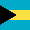
Three equal horizontal bands of aquamarine (top), gold, and aquamarine, with a black equilateral triangle based on the hoist side; the band colors represent the golden beaches of the islands surrounded by the aquamarine sea; black represents the vigor and force of a united people, while the pointing triangle indicates the enterprise and determination of the Bahamian people to develop the rich resources of land and sea.

Lucayan Indians inhabited the islands when Christopher COLUMBUS first set foot in the New World on San Salvador in 1492. British settlement of the islands began in 1647; the islands became a colony in 1783. Piracy thrived in the 17th and 18th centuries because of The Bahamas close proximity to shipping lanes. Since attaining independence from the UK in 1973, The Bahamas has prospered through tourism, international banking, and investment management. Because of its location, the country is a major transshipment point for illegal drugs, particularly shipments to the US and Europe, and its territory is used for smuggling illegal migrants into the US.
Geography
| Area | ||
|---|---|---|
| Total (World Rank: 161) | 13,880 | sq km |
| Land (World Rank: 167) | 10,010 | sq km |
| Water (World Rank: 75) | 3,870 | sq km |
| Forest (World Rank: 200) | 0.20 | % |
| Comparative | slightly smaller than Connecticut | |
| Coastline | ||
| 3542 | ||
| Elevation | ||
| Highest point (World Rank: 227) | 64 | m |
| Agricultural land | ||
| Total (World Rank: 218) | 1.40 | % |
| Arable (World Rank: 201) | 0.80 | % |
| Permanent crops (World Rank: 154) | 0.40 | % |
| Permanent pastures (World Rank: 200) | 0.20 | % |
| Irrigated land (World Rank: 170) | 10 | sq km |
| Map reference | ||
| Central America and the Caribbean | ||
| Environment | ||
| Issues |
| |
| Agreement party |
| |
| Hazzards | hurricanes and other tropical storms cause extensive flood and wind damage | |
| Location | ||
| chain of islands in the North Atlantic Ocean, southeast of Florida, northeast of Cuba | ||
| Climate | ||
| tropical marine; moderated by warm waters of Gulf Stream | ||
| Terrain | ||
| long, flat coral formations with some low rounded hills | ||
People
| Population | ||
|---|---|---|
| Total (World Rank: 178) | 329,988 | |
| Deathrate (World Rank: 125) | 0.72 | % |
| Birthrate (World Rank: 123) | 1.53 | % |
| Growthrate (World Rank: 127) | 0.81 | % |
| Fertility rate (World Rank: 125) | 1.94 | % |
| Median age | ||
| Male (World Rank: 102) | 30.90 | |
| Female (World Rank: 92) | 33.20 | |
| Age structure | ||
| 0 14 male (World Rank: 178) | 37,760 | |
| 0 14 female (World Rank: 178) | 36,667 | |
| 15 24 male (World Rank: 177) | 27,415 | |
| 15 24 female (World Rank: 177) | 26,703 | |
| 25 54 male (World Rank: 176) | 73,016 | |
| 25 54 female (World Rank: 176) | 72,626 | |
| 55 64 male (World Rank: 178) | 13,647 | |
| 55 64 female (World Rank: 175) | 16,567 | |
| 65 x male (World Rank: 179) | 9,843 | |
| 65 x female (World Rank: 173) | 15,744 | |
| Health | ||
| Infant mortality rate (World Rank: 124) | 1.13 | % |
| Life expectancy total (World Rank: 143) | 73 | years |
| Life expectancy female (World Rank: 145) | 75 | years |
| Life expectancy male (World Rank: 139) | 70 | years |
| Physicians per 1000 (World Rank: 52) | 2.72 | |
| Hospital bed per 1000 (World Rank: 77) | 2.90 | |
| Sanitation access total (World Rank: 87) | 92.00 | % |
| Obesity adult (World Rank: 21) | 31.60 | % |
| Drinking water access (World Rank: 73) | 98.40 | % |
Energy
| Electricity | ||
|---|---|---|
| Production (World Rank: 140) | 1,807,000,000 | kWh |
| Consumption (World Rank: 146) | 1,681,000,000 | kWh |
| Source fossil (World Rank: 28) | 99.80 | % |
| Source renew (World Rank: 156) | 0.20 | % |
| Refined products | ||
| Consumption (World Rank: 128) | 24,000 | bbl / day |
| Export (World Rank: 106) | 923 | bbl / day |
| Import (World Rank: 103) | 26,330 | bbl / day |
| Carbon footprint | ||
| 4100000 | ||
Nation
| Budget | ||
|---|---|---|
| Health (World Rank: 61) | 8 | % of GDP |
| Surplus (World Rank: 157) | -6 | % of GDP |
| National symbol | ||
| Yellow Elder flower | ||
| National colours | ||
| yellow | ||
| Adjective | ||
| Bahamian | ||
| Noun | ||
| Bahamian(s) | ||
| Background | ||
| Lucayan Indians inhabited the islands when Christopher COLUMBUS first set foot in the New World on San Salvador in 1492. British settlement of the islands began in 1647; the islands became a colony in 1783. Piracy thrived in the 17th and 18th centuries because of The Bahamas close proximity to shipping lanes. Since attaining independence from the UK in 1973, The Bahamas has prospered through tourism, international banking, and investment management. Because of its location, the country is a major transshipment point for illegal drugs, particularly shipments to the US and Europe, and its territory is used for smuggling illegal migrants into the US. | ||
| Flag description | ||
| three equal horizontal bands of aquamarine (top), gold, and aquamarine, with a black equilateral triangle based on the hoist side; the band colors represent the golden beaches of the islands surrounded by the aquamarine sea; black represents the vigor and force of a united people, while the pointing triangle indicates the enterprise and determination of the Bahamian people to develop the rich resources of land and sea | ||
Economy
| Gdp | ||
|---|---|---|
| Purchasing power parity (World Rank: 161) | 9,017,000,000 | USD |
| Real growth rate (World Rank: 188) | -0.30 | % |
| Per capita purchasing power parity (World Rank: 77) | 24,500 | USD |
| Source agriculture (World Rank: 173) | 2.20 | % |
| Source industry (World Rank: 210) | 7.60 | % |
| Source service (World Rank: 8) | 90.10 | % |
| Labourforce | ||
| Total (World Rank: 170) | 196,900 | |
| In poverty (World Rank: 151) | 9.30 | % |
| Products | ||
| Industries |
| |
| Agriculture |
| |
| Exports |
| |
| Imports |
| |
Communication
| Phone | ||
|---|---|---|
| Landline total (World Rank: 137) | 121,088 | |
| Landline per 100 (World Rank: 46) | 37.00 | |
| Mobile per 100 (World Rank: 104) | 110.00 | |
| Assessment | 0 | |
| Internet | ||
| Users (World Rank: 163) | 261,853 | |
| Population (World Rank: 43) | 80.00 | % |
Transport
| Air | ||
|---|---|---|
| Airports paved (World Rank: 71) | 24.00 | |
| Airports unpaved (World Rank: 74) | 37.00 | |
| Heliports (World Rank: 105) | 1.00 | |
| Road | ||
| Total length (World Rank: 170) | 2,700 | |
| Paved length (World Rank: 132) | 1,620 | |
| Unpaved length (World Rank: 122) | 1,080 | |
This is a list of famous places in this country in alphabetical order.
 Abraham's Bay
- Adderly
- Adelaide
- Albert Town
- Alice Town
- Andros Town
- Arthur's Town
- Bailey Town
- Bain Town
- Baraterre
- Behring Point
- Bennett's Harbour
- Black Point
- Braudies Point
- Burnt Ground
- Cherokee Sound
- Chub Cay
- Clarence Town
- Coakley Town
- Cockburn Town
- Colebrooke Dale
- Colonel Hill
- Cooper's Town
- Coral Harbour
- Creek Village
- Cunningham
- Current
- Davis Harbor
- Devil's Point
- Driggs Hill
- Duncan Town
- Dunmore Town
- Eight Mile Rock
- Farmer's Hill
- Forbes Hill
- Freeport
- Gambier Village
- George Town
- Governor's Harbour
- Great Guana Cay
- Green Turtle Cay
- Gregory Town
- Hard Bargain
- High Rock
- Hope Town
- Hunters
- James Cistern
- Kemps Bay
- Landrail Point
- Louis Town
- Love
- Lucaya
- Macbride
- Mangrove Cay
- Mars Bay
- Marsh Harbour
- Masons Bay
- Mastic Point
- Mather Town
- Matthew Town
- McLeans Town
- Michelson
- Minns
- Nassau
- New Bight
- Nicholls Town
- North Palmetto Point
- Orange Hill
- Palmetto Point
- Pelican Point
- Pinders Point
- Pirates Well
- Port Boyd
- Port Nelson
- Port Royal
- Ramsey
- Rokers Point Settlement
- Rolleville
- Russell Town
- San Andros
- Savannah Sound
- Scrub Hill
- Seymour's
- Snug Corner
- South Palmetto Point
- South Palmetto Point
- Spanish Wells
- Stafford Creek
- Stella Maris
- Steventon
- Sweeting Cay
- Tarpum Bay
- The Bight
- The Bluff
- The Lot
- Tusculum
- Waterloo
- Wemyss Bight
- West End
- William's Town