Azerbaijan
in Western Asia
Asia
 Armenia
 Georgia
 Iran
Iran Russia
 Turkey
- Currency and Currency Code:
- Manat - AZM
- Spoken languages:
- Azerbaijani, Russian, Armenian
- Local electricity:
- 220 V - 50 Hz (plugs: C, F)
- Mobile phone / cellular frequencies (MHz):
- 900 MHz, 1800 MHz, 3G, 4G
- ISO 2-Letter code:
- AZ
- Internet top level domain:
- .az
- Country phone prefix:
- +994
- Local Time (capital):
- Timezone:
- UTC/GMT offset: hours
Safety Score: 3,3 of 5.0 based on data from 9 authorites. Meaning please reconsider your need to travel to Azerbaijan.
Travel warnings are updated daily. Source: Travel Warning Azerbaijan. Last Update: 2024-04-19 08:03:45
Explore Azerbaijan
Azerbaijan with its capital Baku is located in Asia (Southwestern Asia, bordering the Caspian Sea). It covers some 86,601 square kilometers (about three-quarters the size of Pennsylvania) with a population of 9,961,400. Azerbaijani, Russian and Armenian are the languages spoken by people in Azerbaijan (consider regional differences). Armenia, Georgia, Iran, Russia and Turkey are bordering countries.
Azerbaijan is a Turkic state in the Caucasus of Southeastern Europe and Asia. It achieved independence after the collapse of the Soviet Union in 1991. Azerbaijan is known for having nine of the 11 existing ecological zones, although a great deal of it is dry and semiarid steppe. To enter Azerbaijan, an entry visa is required for most countries. If you are planning your visit from your home country, it is a good idea to try to get your visa from an Azerbaijani consulate. Buses, minibuses (marshrutka), and taxis connect most cities. There is often a hub such as a bus station near the bazaar in these cities. The fares for buses and minibuses are posted usually in both old and new manat(qupik). Keep in mind that import and export of manat (local currency) is strictly forbidden.
Popular Destinations in Azerbaijan
Administrative regions of Azerbaijan
- Absheron Rayon
- Aghdam Rayon
- Aghdash Rayon
- Aghjabadi Rayon
- Aghstafa Rayon
- Aghsu Rayon
- Astara District
- Baku City
- Balakan Rayon
- Barda Rayon
- Beylagan Rayon
- Bilasuvar Rayon
- Dashkasan Rayon
- Fizuli Rayon
- Gadabay Rayon
- Ganja City
- Gobustan Rayon
- Goranboy Rayon
- Goychay Rayon
- Goygol Rayon
- Hajigabul Rayon
- Imishli Rayon
- Ismayilli Rayon
- Jabrayil District
- Jalilabad
- Kalbajar District
- Khachmaz Rayon
- Khizi Rayon
- Khojavend District
- Kurdamir Rayon
- Lacin Rayonu
- Lankaran Rayon
- Lankaran Sahari
- Lerik Rayon
- Masally District
- Mingacevir City
- Naftalan City
- Nakhchivan
- Nakhchivan Autonomous Republic
- Neftchala Rayon
- Oghuz Rayon
- Qabala Rayon
- Qakh Rayon
- Qazakh Rayon
- Quba Rayon
- Qubadli Rayon
- Qusar Rayon
- Saatly Rayon
- Sabirabad Rayon
- Salyan Rayon
- Samukh Rayon
- Shabran Rayon
- Shaki Rayon
- Shaki city
- Shamakhi Rayon
- Shamkir Rayon
- Shirvan
- Shusha
- Siazan Rayon
- Sumqayit City
- Susa Rayonu
- Tartar Rayon
- Tovuz Rayon
- Ujar Rayon
- Xankandi Sahari
- Xocali Rayonu
- Yardymli Rayon
- Yevlakh Rayon
- Yevlax City
- Zangilan Rayon
- Zaqatala Rayon
- Zardab Rayon
About the country
The topography is large, flat Kur-Araz Ovaligi (Kura-Araks Lowland, much of it below sea level) with Great Caucasus Mountains to the north, Qarabag Yaylasi (Karabakh Upland) to the west with Baku lies on Abseron Yasaqligi (Apsheron Peninsula) that juts into Caspian Sea. The average density of population is about 115 per km². The climate in Azerbaijan can be described as dry, semiarid steppe. Potential natural disasters are droughts.
To reach someone Azerbaijan dial +994 prior to a number. The local cellular networks are operated on 900 MHz, 1800 MHz, 3G, 4G. Websites typically end with the top level domain ".az". If you want to bring electric appliances (e.g. battery chaarger), keep in min the local 220 V - 50 Hz (plugs: C, F). The sign for the locally used currency Manat is AZM.
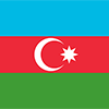
Three equal horizontal bands of sky blue (top), red, and green; a crescent and eight-pointed star in white are centered in the red band; the blue band recalls Azerbaijan's Turkic heritage, red stands for modernization and progress, and green refers to Islam; the crescent moon and star are a Turkic insignia; the eight star points represent the eight Turkic peoples of the world.

Azerbaijan - a nation with a majority-Turkic and majority-Shia Muslim population - was briefly independent (from 1918 to 1920) following the collapse of the Russian Empire; it was subsequently incorporated into the Soviet Union for seven decades. Azerbaijan has yet to resolve its conflict with Armenia over Nagorno-Karabakh, a primarily ethnic Armenian-populated region that Moscow recognized in 1923 as an autonomous republic within Soviet Azerbaijan after Armenia and Azerbaijan disputed the territory's status. Armenia and Azerbaijan reignited their dispute over the area in 1988; the struggle escalated militarily after both countries attained independence from the Soviet Union in 1991. By May 1994, when a cease-fire took hold, ethnic Armenian forces held not only Nagorno-Karabakh but also seven surrounding provinces in the territory of Azerbaijan. The OSCE Minsk Group, co-chaired by the US, France, and Russia, is the framework established to mediate a peaceful resolution of the conflict. Corruption in the country is widespread, and the government, which eliminated presidential term limits in a 2009 referendum and approved extending presidential terms from 5 to 7 years in 2016, has been accused of authoritarianism. Although the poverty rate has been reduced and infrastructure investment has increased substantially in recent years due to revenue from oil and gas production, reforms have not adequately addressed weaknesses in most government institutions, particularly in the education and health sectors, as well as the court system.
Geography
| Area | ||
|---|---|---|
| Total (World Rank: 114) | 86,600 | sq km |
| Land (World Rank: 113) | 82,629 | sq km |
| Water (World Rank: 73) | 3,971 | sq km |
| Forest (World Rank: 49) | 32.10 | % |
| Comparative | about three-quarters the size of Pennsylvania; slightly smaller than Maine | |
| Note | includes the exclave of Naxcivan Autonomous Republic and the Nagorno-Karabakh region; the region's autonomy was abolished by Azerbaijani Supreme Soviet on 26 November 1991 | |
| Landborder | ||
| 2468 | ||
| Elevation | ||
| Lowest point (World Rank: 55) | -28 | m |
| Highest point (World Rank: 37) | 4,466 | m |
| Agricultural land | ||
| Total (World Rank: 51) | 57.60 | % |
| Arable (World Rank: 46) | 22.80 | % |
| Permanent crops (World Rank: 78) | 2.70 | % |
| Permanent pastures (World Rank: 49) | 32.10 | % |
| Irrigated land (World Rank: 39) | 14,277 | sq km |
| Map reference | ||
| Asia | ||
| Environment | ||
| Issues |
| |
| Agreement party |
| |
| Hazzards | droughts | |
| Location | ||
| Southwestern Asia, bordering the Caspian Sea, between Iran and Russia, with a small European portion north of the Caucasus range | ||
| Climate | ||
| dry, semiarid steppe | ||
| Terrain | ||
| large, flat Kur-Araz Ovaligi (Kura-Araks Lowland, much of it below sea level) with Great Caucasus Mountains to the north, Qarabag Yaylasi (Karabakh Upland) to the west; Baku lies on Abseron Yasaqligi (Apsheron Peninsula) that juts into Caspian Sea | ||
People
| Population | ||
|---|---|---|
| Total (World Rank: 90) | 9,961,400 | |
| Deathrate (World Rank: 127) | 0.71 | % |
| Birthrate (World Rank: 115) | 1.58 | % |
| Growthrate (World Rank: 123) | 0.87 | % |
| Fertility rate (World Rank: 136) | 1.89 | % |
| Median age | ||
| Male (World Rank: 112) | 29.80 | |
| Female (World Rank: 94) | 33.00 | |
| Age structure | ||
| 0 14 male (World Rank: 89) | 1,220,360 | |
| 0 14 female (World Rank: 94) | 1,065,510 | |
| 15 24 male (World Rank: 87) | 775,422 | |
| 15 24 female (World Rank: 89) | 703,027 | |
| 25 54 male (World Rank: 77) | 2,219,610 | |
| 25 54 female (World Rank: 73) | 2,302,360 | |
| 55 64 male (World Rank: 75) | 467,830 | |
| 55 64 female (World Rank: 69) | 545,505 | |
| 65 x male (World Rank: 95) | 253,679 | |
| 65 x female (World Rank: 86) | 408,094 | |
| Health | ||
| Infant mortality rate (World Rank: 70) | 2.38 | % |
| Life expectancy total (World Rank: 141) | 73 | years |
| Life expectancy female (World Rank: 132) | 76 | years |
| Life expectancy male (World Rank: 145) | 70 | years |
| Physicians per 1000 (World Rank: 26) | 3.40 | |
| Hospital bed per 1000 (World Rank: 43) | 4.70 | |
| Sanitation access total (World Rank: 102) | 89.30 | % |
| Obesity adult (World Rank: 107) | 19.90 | % |
| Drinking water access (World Rank: 146) | 87.00 | % |
Energy
| Electricity | ||
|---|---|---|
| Production (World Rank: 72) | 23,300,000,000 | kWh |
| Consumption (World Rank: 70) | 20,270,000,000 | kWh |
| Export (World Rank: 71) | 265,000,000 | kWh |
| Import (World Rank: 95) | 108,000,000 | kWh |
| Source fossil (World Rank: 79) | 84.50 | % |
| Source nuclear (World Rank: 101) | 14.60 | % |
| Source renew (World Rank: 134) | 1.00 | % |
| Crude oil | ||
| Production (World Rank: 22) | 833,500 | bbl / day |
| Exports (World Rank: 18) | 721,600 | bbl / day |
| Proved reserves (World Rank: 20) | 7,000,000,000 | bbl |
| Refined products | ||
| Production (World Rank: 59) | 142,100 | bbl / day |
| Consumption (World Rank: 80) | 101,000 | bbl / day |
| Export (World Rank: 54) | 46,770 | bbl / day |
| Import (World Rank: 156) | 6,171 | bbl / day |
| Natural gas | ||
| Production (World Rank: 26) | 29,370,000,000 | m³ |
| Consumption (World Rank: 44) | 18,200,000,000 | m³ |
| Export (World Rank: 26) | 7,320,000,000 | m³ |
| Import (World Rank: 58) | 0 | m³ |
| Carbon footprint | ||
| 35000000 | ||
Nation
| Budget | ||
|---|---|---|
| Education (World Rank: 154) | 3 | % of GDP |
| Military (World Rank: 19) | 4 | % of GDP |
| Health (World Rank: 104) | 6 | % of GDP |
| Surplus (World Rank: 49) | -0 | % of GDP |
| National symbol | ||
| flames of fire | ||
| National colours | ||
| red | ||
| Adjective | ||
| Azerbaijani | ||
| Noun | ||
| Azerbaijani(s) | ||
| Background | ||
| Azerbaijan - a nation with a majority-Turkic and majority-Shia Muslim population - was briefly independent (from 1918 to 1920) following the collapse of the Russian Empire; it was subsequently incorporated into the Soviet Union for seven decades. Azerbaijan has yet to resolve its conflict with Armenia over Nagorno-Karabakh, a primarily ethnic Armenian-populated region that Moscow recognized in 1923 as an autonomous republic within Soviet Azerbaijan after Armenia and Azerbaijan disputed the territory's status. Armenia and Azerbaijan reignited their dispute over the area in 1988; the struggle escalated militarily after both countries attained independence from the Soviet Union in 1991. By May 1994, when a cease-fire took hold, ethnic Armenian forces held not only Nagorno-Karabakh but also seven surrounding provinces in the territory of Azerbaijan. The OSCE Minsk Group, co-chaired by the US, France, and Russia, is the framework established to mediate a peaceful resolution of the conflict. Corruption in the country is widespread, and the government, which eliminated presidential term limits in a 2009 referendum and approved extending presidential terms from 5 to 7 years in 2016, has been accused of authoritarianism. Although the poverty rate has been reduced and infrastructure investment has increased substantially in recent years due to revenue from oil and gas production, reforms have not adequately addressed weaknesses in most government institutions, particularly in the education and health sectors, as well as the court system. | ||
| Flag description | ||
| three equal horizontal bands of sky blue (top), red, and green; a crescent and eight-pointed star in white are centered in the red band; the blue band recalls Azerbaijan's Turkic heritage, red stands for modernization and progress, and green refers to Islam; the crescent moon and star are a Turkic insignia; the eight star points represent the eight Turkic peoples of the world | ||
Economy
| Gdp | ||
|---|---|---|
| Purchasing power parity (World Rank: 72) | 165,700,000,000 | USD |
| Real growth rate (World Rank: 206) | -3.10 | % |
| Per capita purchasing power parity (World Rank: 94) | 17,500 | USD |
| Source agriculture (World Rank: 118) | 6.00 | % |
| Source industry (World Rank: 7) | 51.70 | % |
| Source service (World Rank: 197) | 42.30 | % |
| Labourforce | ||
| Total (World Rank: 81) | 5,032,000 | |
| In poverty (World Rank: 162) | 4.90 | % |
| Products | ||
| Industries |
| |
| Agriculture |
| |
| Exports |
| |
| Imports |
| |
Communication
| Phone | ||
|---|---|---|
| Landline total (World Rank: 60) | 1,700,230 | |
| Landline per 100 (World Rank: 108) | 17.00 | |
| Mobile per 100 (World Rank: 129) | 104.00 | |
| Assessment | 0 | |
| Internet | ||
| Users (World Rank: 55) | 7,720,500 | |
| Population (World Rank: 52) | 78.20 | % |
Transport
| Air | ||
|---|---|---|
| Airports paved (World Rank: 60) | 30.00 | |
| Airports unpaved (World Rank: 142) | 7.00 | |
| Heliports (World Rank: 84) | 1.00 | |
| Rail | ||
| Total length (World Rank: 62) | 2,944 | |
| Road | ||
| Total length (World Rank: 76) | 52,942 | |
| Paved length (World Rank: 57) | 26,789 | |
| Unpaved length (World Rank: 57) | 26,153 | |
This is a list of famous places in this country in alphabetical order.
 Agdam
Agdam- Agdas
- Agdzhabedy
- Aghstafa
- Aghsu
- Amirdzhan
- Askyaran
- Astara
- Badamdar
- Bakixanov
- Baku
- Balakhani
- Barda
- Belokany
- Beylagan
- Bilajari
- Biny Selo
- Boradigah
- Buzovna
- Cinarli
- Corat
- Culfa
- Divichibazar
- Dzhalilabad
- Fizuli
- Ganja
- Geoktschai
- Goranboy
- Goygol
- Haci Zeynalabdin
- Haciqabul
- Hadrut
- Hovsan
- Imishli
- Ismayilli
- Jebrail
- Kerbakhiar
- Khirdalan
- Khyzy
- Kyadabek
- Kyurdarmir
- Lacin
- Lankaran
- Lerik
- Lokbatan
- Mardakan
- Martakert
- Masally
- Mastaga
- Mingachevir
- Naftalan
- Nakhichivan
- Neftcala
- Novyy Karanlug
- Oguz
- Ordubad
- Pirallahi
- Pushkino
- Qala
- Qaracuxur
- Qarayeri
- Qax
- Qax Ingiloy
- Qazax
- Qobustan
- Qobustan
- Quba
- Qubadli
- Qusar
- Qutqashen
- Saatli
- Sabirabad
- Sabuncu
- Sahbuz
- Salyan
- Samux
- Severo-Vostotchnyi Bank
- Shamakhi
- Shamkhor
- Sharur City
- Sheki
- Shushi
- Sirvan
- Sumqayit
- Terter
- Tovuz
- Ujar
- Xacmaz
- Xankandi
- Xocali
- Xudat
- Yardimli
- Yayci
- Yeni Suraxani
- Yevlakh
- Yukhary-Dashkesan
- Zangilan
- Zaqatala
- Zardob
- Zyrya