Antigua and Barbuda
in Caribbean
North America
- Currency and Currency Code:
- Dollar - XCD
- Spoken languages:
- English
- Local electricity:
- 230 V - 60 Hz (plugs: A, B)
- Mobile phone / cellular frequencies (MHz):
- 850 MHz, 900 MHz, 1900 MHz, 3G, 4G
- ISO 2-Letter code:
- AG
- Internet top level domain:
- .ag
- Country phone prefix:
- +1-268
- Local Time (capital):
- Timezone:
- UTC/GMT offset: hours
Safety Score: 2,5 of 5.0 based on data from 9 authorites. Meaning we advice caution when travelling to Antigua and Barbuda.
Travel warnings are updated daily. Source: Travel Warning Antigua and Barbuda. Last Update: 2024-04-19 08:03:45
Explore Antigua and Barbuda
Antigua and Barbuda with its capital Saint John's is located in North America (Caribbean, islands between the Caribbean Sea and the North Atlantic Ocean). It covers some 444 square kilometers (2.5 times the size of Washington, DC) with 94,731 citizens. English is the official language used in Antigua and Barbuda. Thiscountry has no land-based border with any other country.
Antigua and Barbuda are two Caribbean islands (Antigua, pronounced an-tee'-gah and Barbuda), that form a country that lies between the Caribbean Sea and the North Atlantic Ocean, east-southeast of Puerto Rico, off the coast of South America. With few other natural resources, the climate is tropical marine with little seasonal temperature variation. The islands experience hurricanes and tropical storms (July to October), and periodic droughts. Early settlements by the Spanish and French were succeeded by the English who formed a colony in 1667. Slavery, established to run the sugar plantations on Antigua, was abolished in 1834. The islands became an independent state within the British Commonwealth of Nations in 1981.
Popular Destinations in Antigua and Barbuda
Administrative regions of Antigua and Barbuda
- Barbuda
- Parish of Saint George
- Parish of Saint John
- Parish of Saint Mary
- Parish of Saint Paul
- Parish of Saint Peter
- Parish of Saint Philip
- Redonda
About the country
The topography is mostly low-lying limestone and coral islands, with some higher volcanic areas. The average density of population is about 214 per km². The climate in Antigua and Barbuda can be described as tropical maritime with little seasonal temperature variation. Potential natural disasters are hurricanes and tropical storms (July to October) periodic droughts
To reach someone Antigua and Barbuda dial +1-268 prior to a number. The local cellular networks are operated on 850 MHz, 900 MHz, 1900 MHz, 3G, 4G. Websites typically end with the top level domain ".ag". If you want to bring electric appliances (e.g. battery chaarger), keep in min the local 230 V - 60 Hz (plugs: A, B). The sign for the locally used currency Dollar is XCD.
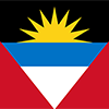
Red, with an inverted isosceles triangle based on the top edge of the flag; the triangle contains three horizontal bands of black (top), light blue, and white, with a yellow rising sun in the black band; the sun symbolizes the dawn of a new era, black represents the African heritage of most of the population, blue is for hope, and red is for the dynamism of the people; the "V" stands for victory; the successive yellow, blue, and white coloring is also meant to evoke the country's tourist attractions of sun, sea, and sand.

The Siboney were the first people to inhabit the islands of Antigua and Barbuda in 2400 B.C., but Arawak Indians populated the islands when COLUMBUS landed on his second voyage in 1493. Early Spanish and French settlements were succeeded by an English colony in 1667. Slavery, established to run the sugar plantations on Antigua, was abolished in 1834. The islands became an independent state within the British Commonwealth of Nations in 1981. On 6 September 2017, Hurricane Irma passed over the island of Barbuda devastating the island and forcing the evacuation of the population to Antigua. Almost all the structures on Barbuda were destroyed and the vegetation stripped, but Antigua was spared the worst.
Geography
| Area | ||
|---|---|---|
| Total (World Rank: 200) | 443 | sq km |
| Land (World Rank: 197) | 443 | sq km |
| Forest (World Rank: 134) | 9.10 | % |
| Comparative | 2.5 times the size of Washington, DC | |
| Note | includes Redonda, 1.6 sq km | |
| Coastline | ||
| 153 | ||
| Elevation | ||
| Highest point (World Rank: 199) | 402 | m |
| Agricultural land | ||
| Total (World Rank: 163) | 20.50 | % |
| Arable (World Rank: 118) | 9.10 | % |
| Permanent crops (World Rank: 84) | 2.30 | % |
| Permanent pastures (World Rank: 134) | 9.10 | % |
| Irrigated land (World Rank: 177) | 1 | sq km |
| Map reference | ||
| Central America and the Caribbean | ||
| Environment | ||
| Issues |
| |
| Agreement party |
| |
| Hazzards |
| |
| Location | ||
| Caribbean, islands between the Caribbean Sea and the North Atlantic Ocean, east-southeast of Puerto Rico | ||
| Climate | ||
| tropical maritime; little seasonal temperature variation | ||
| Terrain | ||
| mostly low-lying limestone and coral islands, with some higher volcanic areas | ||
People
| Population | ||
|---|---|---|
| Total (World Rank: 195) | 94,731 | |
| Deathrate (World Rank: 173) | 0.57 | % |
| Birthrate (World Rank: 117) | 1.57 | % |
| Growthrate (World Rank: 91) | 1.21 | % |
| Migration rate (World Rank: 44) | 0.22 | % |
| Fertility rate (World Rank: 118) | 2.00 | % |
| Median age | ||
| Male (World Rank: 109) | 30.00 | |
| Female (World Rank: 89) | 33.50 | |
| Age structure | ||
| 0 14 male (World Rank: 193) | 11,116 | |
| 0 14 female (World Rank: 193) | 10,760 | |
| 15 24 male (World Rank: 192) | 7,939 | |
| 15 24 female (World Rank: 192) | 8,008 | |
| 25 54 male (World Rank: 196) | 18,268 | |
| 25 54 female (World Rank: 191) | 21,695 | |
| 55 64 male (World Rank: 196) | 4,179 | |
| 55 64 female (World Rank: 194) | 5,130 | |
| 65 x male (World Rank: 199) | 3,279 | |
| 65 x female (World Rank: 198) | 4,357 | |
| Health | ||
| Infant mortality rate (World Rank: 117) | 1.21 | % |
| Life expectancy total (World Rank: 82) | 77 | years |
| Life expectancy female (World Rank: 91) | 79 | years |
| Life expectancy male (World Rank: 73) | 75 | years |
| Hospital bed per 1000 (World Rank: 103) | 2.10 | |
| Sanitation access total (World Rank: 91) | 91.40 | % |
| Obesity adult (World Rank: 115) | 18.90 | % |
| Drinking water access (World Rank: 82) | 97.90 | % |
Energy
| Electricity | ||
|---|---|---|
| Production (World Rank: 176) | 330,000,000 | kWh |
| Consumption (World Rank: 181) | 306,900,000 | kWh |
| Source fossil (World Rank: 46) | 96.60 | % |
| Source renew (World Rank: 97) | 4.60 | % |
| Refined products | ||
| Consumption (World Rank: 175) | 5,000 | bbl / day |
| Export (World Rank: 120) | 91 | bbl / day |
| Import (World Rank: 166) | 4,884 | bbl / day |
| Carbon footprint | ||
| 600000 | ||
Nation
| Budget | ||
|---|---|---|
| Education (World Rank: 155) | 3 | % of GDP |
| Health (World Rank: 127) | 6 | % of GDP |
| Surplus (World Rank: 71) | -2 | % of GDP |
| National symbol | ||
| fallow deer | ||
| National colours | ||
| yellow | ||
| Adjective | ||
| Antiguan, Barbudan | ||
| Noun | ||
| Antiguan(s), Barbudan(s) | ||
| Background | ||
| The Siboney were the first people to inhabit the islands of Antigua and Barbuda in 2400 B.C., but Arawak Indians populated the islands when COLUMBUS landed on his second voyage in 1493. Early Spanish and French settlements were succeeded by an English colony in 1667. Slavery, established to run the sugar plantations on Antigua, was abolished in 1834. The islands became an independent state within the British Commonwealth of Nations in 1981. On 6 September 2017, Hurricane Irma passed over the island of Barbuda devastating the island and forcing the evacuation of the population to Antigua. Almost all the structures on Barbuda were destroyed and the vegetation stripped, but Antigua was spared the worst. | ||
| Flag description | ||
| red, with an inverted isosceles triangle based on the top edge of the flag; the triangle contains three horizontal bands of black (top), light blue, and white, with a yellow rising sun in the black band; the sun symbolizes the dawn of a new era, black represents the African heritage of most of the population, blue is for hope, and red is for the dynamism of the people; the "V" stands for victory; the successive yellow, blue, and white coloring is also meant to evoke the country's tourist attractions of sun, sea, and sand | ||
Economy
| Gdp | ||
|---|---|---|
| Purchasing power parity (World Rank: 192) | 2,288,000,000 | USD |
| Real growth rate (World Rank: 35) | 5.30 | % |
| Per capita purchasing power parity (World Rank: 73) | 25,400 | USD |
| Source agriculture (World Rank: 167) | 2.30 | % |
| Source industry (World Rank: 151) | 20.20 | % |
| Source service (World Rank: 32) | 77.50 | % |
| Labourforce | ||
| Total (World Rank: 202) | 30,000 | |
| Products | ||
| Industries |
| |
| Agriculture |
| |
| Exports |
| |
| Imports |
| |
Communication
| Phone | ||
|---|---|---|
| Landline total (World Rank: 171) | 22,504 | |
| Landline per 100 (World Rank: 69) | 24.00 | |
| Mobile per 100 (World Rank: 44) | 136.00 | |
| Assessment | 0 | |
| Internet | ||
| Users (World Rank: 184) | 60,000 | |
| Population (World Rank: 87) | 65.20 | % |
Transport
| Air | ||
|---|---|---|
| Airports paved (World Rank: 196) | 2.00 | |
| Airports unpaved (World Rank: 180) | 1.00 | |
| Road | ||
| Total length (World Rank: 183) | 1,170 | |
| Paved length (World Rank: 163) | 386 | |
| Unpaved length (World Rank: 125) | 784 | |
This is a list of famous places in this country in alphabetical order.
 Aberdeen
- All Saints
- Barnes Hill
- Bats Cave
- Bendals
- Bethesda
- Betty's Hope
- Bishops
- Blakes
- Blubber Valley
- Bolands
- Boon House
- Branns Hamlet
- Buckleys
- Burkes
- Cassada Gardens
- Cedar Grove
- Christian Hill
- Clare Hall
- Clarence House
- Cobbs Cross
- Cochranes
- Coconut Hall
- Codrington
- Collins
- Comfort Hall
- Crab Hill
- Creekside
- Crosbies
- Delaps
- Dulcina
- Ebenezer
- Emanuel
- English Harbour Town
- Falmouth
- Ffryes
- Five Islands Village
- Freemans
- Freemans Village
- Freetown
- Gilberts
- Glanvilles
- Golden Grove
- Grants
- Grays
- Grays Hill
- Green Bay
- Guadeloupe
- Gunthorpes
- Hamiltons
- Harveys
- Jennings
- John Hughes
- Johnsons Point
- Jolly Harbour
- Liberta
- Little Duers
- Long Lane
- Lower Lyons
- Lyons
- Matthews
- Mill Reef Club
- Montpelier
- Morris Loobys
- Mount William
- New Division
- New Winthorpes
- Newfield
- Old Road
- Osbourn
- Pares
- Parham
- Pattersons
- Pattersons Dwelling House
- Paynters
- Piggotts
- Potters Village
- Redonda
- Saint John's
- Saint Johnston Village
- Saint Lukes
- Saint Philips
- Sawcolts
- Sea View Farm
- Seaforths
- Seatons
- Sutherlands Development
- Swetes
- Table Hill Gordon
- The Brook
- The Diamond
- The Grove
- Urlings
- Vernons
- Watsons
- Weatherills
- Willikies
- Willoughby
- Woods